|
||

|

|
|

|
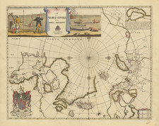
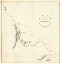
This pair of maps, collectively titled "Originalkarte zur Übersicht des Standpunktes neuester Polarforschungen bis Ende September 1874" alongside the "Provisorische Skizze von Franz Joseph Land," provides a fine overview of Arctic exploration up until the end of September 1874.
Smith Sound Expeditions (Colored Orange)
- 1816: Bylot & Baffin
- 1818: John Ross
- 1826: William Edward Parry
- 1852: Elisha Kent Kane
- 1860/61: Isaac Israel Hayes
- 1871: Charles Francis Hall
Historical Context: Smith Sound, a passage between Greenland and Canada, was repeatedly explored for a Northwest Passage. The expeditions by notable explorers like Baffin and Ross laid early claims to polar exploration, but it was Parry, Kane, Hayes, and Hall who advanced the understanding of the Arctic, facing extreme conditions to map uncharted territories.
East Greenland Expeditions (Colored Green)
- Since 1607: Henry Hudson, and others
- 1822: William Scoresby
- 1823: Douglas Clavering
- 1869/70: Carl Koldewey
Historical Context: East Greenland was a mystery for centuries since Hudson's time. The later expeditions of Scoresby and Clavering provided vital geographical and scientific data. Koldewey's German North Polar Expedition was particularly significant for its scientific contributions and mapping efforts.
Spitzbergen Area Expeditions (Colored Yellow)
- 1868: Spitzbergen
- 1871: A.E. Nordenskiöld
Historical Context: Spitzbergen, known for its strategic location within the Arctic Ocean, attracted expeditions that focused on whaling and later, scientific inquiry. Nordenskiöld's expedition was paramount in expanding glaciological and geological knowledge of the area.
North of Spitzbergen
- 1827-1828: Parry
- 1872-1873: Austria-Hungary
Historical Context: The quest to reach the North Pole saw Parry's and Austria-Hungary's expeditions pushing north of Spitzbergen into the pack ice, enduring extreme polar conditions in pursuit of scientific and national glory.
Northeast of Spitzbergen (Colored Purple)
- 1871: The Austro-Hungarian North Pole Expedition
Historical Context: This expedition, led by Payer and Weyprecht, is noted for the discovery of the archipelago Franz Josef Land, significantly contributing to the cartographic and scientific understanding of the polar region.
Novaya Zemlya (Colored Red)
- 1871: MacDonald
- 1874: Tromsø
Historical Context: Novaya Zemlya, a Russian archipelago in the Arctic Ocean, was a focal point for explorations like MacDonald's, which aimed to find new routes and understand the Arctic environment.
The second map, "Provisorische Skizze von Franz Joseph Land," represents the provisional sketch of Franz Joseph Land, a significant finding by the Austro-Hungarian North Pole Expedition of 1873 and 1874. It underlines the enduring quest of humanity to explore and document the unknown, illustrating the tenacity of explorers who braved the Arctic's perilous environment to expand our geographical frontiers.
August Heinrich Petermann (1822-1878) is a renowned German cartographer of the nineteenth century. Petermann studied cartography at the Geographical Art-School in Potsdam before traveling to Edinburgh to work with Dr. A. Keith Johnston on an English edition of Berghaus’ Physical Atlas. Two years later he moved to London, where he made maps and advised exploratory expeditions as they set off to explore the interior of Africa and the Arctic.
In 1854, Petermann returned to Germany to be Director of the Geographical Institute of Justus Perthes in Gotha. There, he was the editor of the Geographische Mittheilungen and Stieler’s Handatlas. The Royal Geographical Society of London awarded him their Gold Medal in 1860. He continued his interest in exploration in Germany, fundraising for the German Exploring Expeditions of 1868 and 1869-70, which sought an open Arctic sea. Tragically, he committed suicide in 1878.
![[Heightened with Gold] Paskaert Zynde de Noordelijckste Zeekusten van America van Groenland door de Straet Davis en de Straet Hudson tot Terra Neuf . . .](https://storage.googleapis.com/raremaps/img/small/93148.jpg)