|
||

|

|
|

|
Stock# 98470
Description
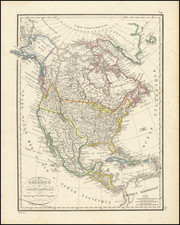
Scarce map of North America, published shortly prior to Texan Independence.
The map shows a 54-40 or fight boundary in the Pacific Northwest, showing the American claims extending far north of its final border as agreed between the US and Britain a decade later.
Upper California is crossed with a number of mythical rivers, running from Lake Timpanagos to Lake Teguayo to the Pacific Ocean via the Rio los Mongos, S. Sacramento, and sevearl unnamed rives.
The map illustrates a massive Oregon Territory, showing the hydrography largely based on Lewis & Clark. A number of Native American Tribes are located.
Alaska is Russian America.
Rarity
This is the first time we have seen this map.

![Charte von Nord-America Prag 1818 [Rare Alaska Inset Map]](https://storage.googleapis.com/raremaps/img/small/72184.jpg)