


|
||

|

|
|

|
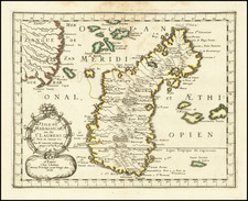
Decorative map of Madagascar by the noted Dutch publisher Pieter van der Aa, known at the time as the Isle of St. Lawrence, from the early 18th century. The map is emblematic of the period's expanding European exploration and colonial interests in the Indian Ocean.
Van der Aa's map is an exquisite amalgamation of artistry and maritime navigation science, characterized by its detailed coastal outlines, the plotting of maritime routes, and the intricate compass roses that guide the eye across the ocean expanses. The delineation of Madagascar’s rugged topography and the noted locations of settlements and ports reflect the European powers' burgeoning interest in the strategic and commercial potential of the island.
The map's historical significance is underscored by its depiction of the island at a time when it was becoming increasingly entangled in the networks of European trade and colonial ambition. Madagascar was a nexus for the exchange of goods, including slaves, between Africa, Asia, and Europe, and Van der Aa's map provides valuable insights into the geographic knowledge that underpinned and facilitated these exchanges.
Pieter van der Aa (1659-1733) was a Dutch mapmaker and publisher who printed pirated editions of foreign bestsellers and illustrated books, but is best known for his voluminous output of maps and atlases. Van der Aa was born to a German stonecutter from Holstein. Interestingly, all three van der Aa sons came to be involved in the printing business. Hildebrand was a copper engraver and Boudewyn was a printer.
![[ Madagascar ] Carte Particuliere de l'Isle Dauphine ou Madagascar et St. Laurens . . .](https://storage.googleapis.com/raremaps/img/small/52606.jpg)
![[ Madeira ] Carte Des Isles De Madere Et Porto Santo](https://storage.googleapis.com/raremaps/img/small/101865.jpg)
![[Diego Garcia / Chagos Archipelago] Track of the Calcutta East Indiaman, over the Bassas de Chagas, in the Indian Ocean](https://storage.googleapis.com/raremaps/img/small/66729.jpg)
![XV. b [Cape Verde]](https://storage.googleapis.com/raremaps/img/small/93302.jpg)