


|
||

|

|
|

|
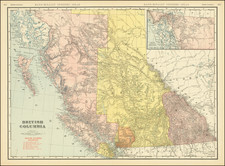
Explore Pacific Rim National Park
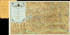
A fine brochure produced by Parks Canada to promote tourism to the Pacific Rim National Park near Vancouver, British Columbia. The map provides a detailed, large-scale depiction of the Pacific Rim National Park, highlighting the primary regions of the park: the Long Beach Unit, the Broken Islands Group, and the West Coast Trail. On the reverse, the brochure showcases the natural splendor of the region with a colorful collage that features scenes of the Tsusiat Falls, the coasts of Long Beach, and some of the Broken Group Islands as well as the diverse wildlife, like sea lions and starfish, that inhabit these parks.
Designed for tourism, this map's main focus is illustrating the many ways to get to Vancouver Island where the park is located. The map has colorful lines extending throughout with each one indicating a different method of travel such as ferries, public logging roads, highways, and even a railroad. Taking up the bottom third of the brochure is text that explains how to get to the park and lists several ferry companies, how frequently they make a trip to the island, the port of call, and how long the journey takes.
![[Run of 6 Volumes] Report Upon Geographical Surveys West of the 100th Meridian](https://storage.googleapis.com/raremaps/img/small/74064.jpg)