|
||

|

|
|

|
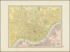
Offering an intricate cartographic perspective of two major cities in late 19th century Ohio, Cleveland [with:] Map of Toledo stands as a noteworthy document of urban and transportation development. Published in Chicago around 1899 by George F. Cram, a distinguished map publisher and entrepreneur, this work delineates not only city boundaries, natural features like Lake Erie and the river, but also the networks of Steam Railroads and Horse Railroads.
At the cusp of a new century, Cleveland was undergoing rapid growth and transformation. This map offers a glimpse into these urban landscapes as they stood in 1898, marked by burgeoning transportation networks that included steam and horse railroads. Such infrastructural advancements were critical to the cities' evolution and played a pivotal role in shaping the patterns of urban and suburban growth.
The map's detailed representation of Cleveland notably includes Wade Park, a significant public space that is still present today. The inclusion of such landmarks, in conjunction with the transportation lines and natural features, provides a comprehensive understanding of the city's geography during this era.
The reverse side of the map features a depiction of Toledo, offering a comparative urban perspective within the same state. This rare dual depiction underscores the relative importance of both cities within Ohio and their distinct urban characteristics.
The Cleveland [with:] Map of Toledo map, therefore, serves as an illuminating historical document, offering invaluable insights into the urban development and transportation infrastructure of late 19th-century Ohio. Its careful detailing and comprehensive approach make it a significant resource for those interested in the historical geography and urban growth of these American cities.
George F. Cram (1842-1928), or George Franklin Cram, was an American mapmaker and businessman. During the Civil War, Cram served under General William Tecumseh Sherman and participated in his March to the Sea. His letters of that time are now important sources for historians of the Civil War. In 1867, Cram and his uncle, Rufus Blanchard, began the company known by their names in Evanston, Illinois.
Two years later, Cram became sole proprietor and the company was henceforth known as George F. Cram Co. Specializing in atlases, Cram was one of the first American companies to publish a world atlas. One of their most famous products was the Unrivaled Atlas of the World, in print from the 1880s to the 1950s.
Cram died in 1928, seven years after he had merged the business with that of a customer, E.A. Peterson. The new company still bore Cram’s name. Four years later, the Cram Company began to make globes, a branch of the business that would continue until 2012, when the company ceased to operate. For the final several decades of the company’s existence it was controlled by the Douthit family, who sold it just before the company was shuttered.
![[Indiana, Ohio, Kentucky, and Virginia] Amer. Sep. No. 50. Partie des États Unis](https://storage.googleapis.com/raremaps/img/small/93543.jpg)