|
||

|

|
|

|
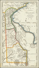
First State
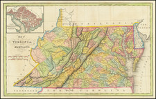
Early Map of the Great State of Maryland
Produced by Samuel Lewis in 1795 for Carey's American Edition of Guthrie's Geography improved, this map features the newly formed states of Maryland and Delaware and the District of Columbia. It was published in Carey's 1795 General Atlas For Carey's Edition Of Guthrie's Geography, which was the first world atlas published in the United States.
The map labels all of Maryland's counties as well as important cities such as Baltimore and Annapolis. This depiction presents a small but growing Maryland. The relatively light depiction of infrastructure and settlement suggests a smaller population, but the inclusion of the still-under-construction capitol in Washington, D.C. illustrates the expansion in prestige the state would soon come to appreciate.
The City of Washington
This map's inclusion of America's new capital is intriguing, especially when one considers the history of the city. While Article I, Section 8 of the U.S. Constitution provided for the establishment of a federal district to serve as the national capital, leaders did not have a location in mind until 1790. In exchange for the federal government assuming the war debts of the states, Maryland and Virginia designated 100 square miles of land to be set aside for the capitol.
The survey to establish the boundaries of Washington was not completed until 1793, only two years before the publication of this map. After the survey, it would be another 7 years, five years after this map's creation, that the United States would officially move its government to Washington. Two years later, Congress established the District of Columbia, granting powers to themselves and the president to administer the City of Washington. In 1802, after a decade of work, Washington D.C. was the administrative area that we would recognize today.
States
This is the first state of the map, without the plate number added in the upper left corner. This plate was replaced in Carey's 1814 atlas.