
This item has been sold, but you can enter your email address to be notified if another example becomes available.


|
||

|

|
|

|
Stock# 9805
Description
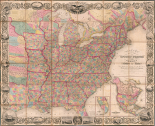
Six maps of the United States, showing (1) the location of the battles during the American Revolution; (2) the US at the time of the Treaty of 1783 settling the Revolution; (3) Territorial acquistions from 1776 to 1876; (4) the Political Divisions in 1815 and (5) Political Divisions in 1850. A wonderful map commenorating the American Centennial.
O.W. Gray Biography
O. W. Gray was a publishing firm based in Philadelphia. Later, they published as O. W. Gray & Son. They published atlases in the late nineteenth century. Gray's National Atlas was one of the most successful commercial ventures of the 1870s and one of the last to employ hand coloring on maps.
![[Map of the United States, illustrating the routes of the Canadian Pacific Railway and the Seattle, Lake Shore and Eastern Railway]](https://storage.googleapis.com/raremaps/img/small/71080.jpg)
![(Extremely Rare American View Book) Les Ports de l'Amerique [8 engraved prints of American Cities: Philadelphia, Boston, Savannah, Fredericksburg, Charlestown, Chesapeake Bay, Quebec, and Port Royal] Graveé d'apres le Tableau de Vernet.](https://storage.googleapis.com/raremaps/img/small/95381.jpg)