


|
||

|

|
|

|
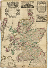
From The First Systematic Survey of Scotland
Detailed map of part of Southeastern Scotland, centered on Edinburgh, based upon the surveys of Timothy Pont.
The 17th century was a period of great cartographic exploration and documentation, with the Low Countries emerging as the epicenter of map-making technology and craft. Timothy Pont, a Scottish minister and cartographer, was instrumental in surveying Scotland during the late 16th and early 17th centuries. His work represented the first systematic attempt to detail the Scottish landscape, an endeavor that offered both geographical and sociopolitical insights during a volatile period of Scottish history.
One of the prominent geographical features on this map is the Firth of Forth, a significant estuary that opens into the North Sea, situated to the north of Edinburgh. The Firth was a vital maritime route, influencing trade, military strategy, and regional politics. Its detailed depiction on the map indicates the level of maritime knowledge available at the time and reflects the strategic importance of the waterway for the kingdom of Scotland.
Includes two decorative cartouches and a dedication with coat of arms, along with a compass rose and sailing ships.
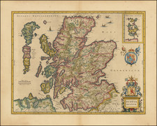
Henricus Hondius (1597-1651) was a Dutch engraver and mapmaker, a member of a prominent cartographic family. His father, Jodocus Hondius, was also an engraver and geographer. While working with his father, Henricus was instrumental in the expansion and republishing of Mercator’s atlas, first published in 1595 and republished by Hondius in 1606.
Upon his father’s death in 1612, Henricus and his brother, Jodocus the Younger, took over the business. He set up his own shop in 1621, where he continued to release new editions of the Mercator atlas. Later, he partnered with his brother-in-law, Jan Janssonius, in continuing to expand and publish Mercator’s atlas, which would become known as the Mercator-Hondius-Janssonius atlas. Born and based in Amsterdam, he died there in 1651.
![[Scotland] Scotiae Tabula](https://storage.googleapis.com/raremaps/img/small/35612.jpg)
![(British Isles) Tabu Moder Anglie & Hiber [Modern Map of England and Ireland]](https://storage.googleapis.com/raremaps/img/small/103164.jpg)