|
||

|

|
|

|
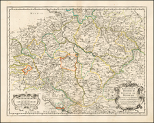
Germany's Historic Tribal Culture
Zatta's map offers a fascinating detailed depiction of ancient Germany, segmented into its significant tribal regions and demarcated by the Danube River.
The map reflects a period of fervent Enlightenment inquiry into the classical past. Originating from a European milieu engaged in the study of ancient cultures, this Venetian work provides an instructive visual narrative of the territorial complexities of ancient Germania, as understood by 18th-century scholars.
During the Enlightenment era, the intellectual exploration of antiquity was not confined to the Mediterranean world but extended to the territories north of the Alps. The ancient Germanic tribes had long been a subject of scholarly interest, both for their interactions with the Roman Empire and for their foundational role in the histories of various European nations.
The map's cartographic features indicate a high level of academic rigor. The delineation into four major tribes and further subdivisions into minor and even lesser groupings reveals a detailed hierarchical understanding of Germanic social and territorial organization.
Issued as part of Zatta's Atlante Novissimo.
Antonio Zatta (fl. 1757-1797) was a prominent Italian editor, cartographer, and publisher. Little is known about his life beyond his many surviving published works. It is possible that he was born as early as 1722 and lived as late as 1804. He lived in Venice and his work flourished between 1757 and 1797. He is best known for his atlas, Atlante Novissimo (1779-1785), and for his prolific output of prints and books that were both precisely made and aesthetically pleasing. Zatta clearly had a large network from which to draw information; this is how he was able to publish the first glimpse of the islands visited by Captain Cook in the Atlante Novissimo. Zatta also published books of plays and architecture.
![Moscovia Parte Orientale . . . [with] Parte Occidentale . . .](https://storage.googleapis.com/raremaps/img/small/26615.jpg)