|
||

|

|
|

|
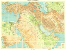
This military map, titled "Medina Second Edition," was published by the War Office in 1944 as a part of the Geographical Section, General Staff, Nº 2555 series, and covers a substantial segment of northwest Saudi Arabia. This edition has been updated from its initial 1921 version.
This map was produced in the immediate aftermath of World War II, a time of geopolitical realignment and imperial interest in the Middle East. The detailed depiction of towns, railways, roads, and tribal areas within the map provides a window into the British military's operational and logistical concerns in the region. Specifically, the inclusion of Medina and other towns of strategic importance, as well as various physical features like rivers, oases, and mountain ranges, demonstrates the comprehensiveness of British reconnaissance and the necessity of such detailed cartography for military planning and administration.
The map was produced by the 17 Map Reproduction Section R.E. in June 1945 from W.O. Kodalines and printed in November 1945 by No. 1 Base Survey Drawing and Photo Process Office.