|
||

|

|
|

|
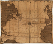
Detailed chart of the North Atlantic Ocean by Jacques Nicolas Bellin, the Royal Geographer to the King of France.
Embellished with an elaborate 32 point compass rose at the center, the map presents a scientific look at navigation across the Atlantic Ocean between Europe, America and the North Parts of Africa, covering the area of the so-called Triangle Trade, which dominated European colonial trade during the 18th Century.
In addition to the 32-point compass rose, the map includes a network of rhumb lines, with a sweeping view of the Atlantic and its bordering lands. It encompasses a considerable stretch of North America, charting territories from Florida through the Carolinas, Virginia, Pennsylvania, and up to New England, Nova Scotia, and further north.
Jacques-Nicolas Bellin (1703-1772) was among the most important mapmakers of the eighteenth century. In 1721, at only the age of 18, he was appointed Hydrographer to the French Navy. In August 1741, he became the first Ingénieur de la Marine of the Dépôt des cartes et plans de la Marine (the French Hydrographic Office) and was named Official Hydrographer of the French King.
During his term as Official Hydrographer, the Dépôt was the one of the most active centers for the production of sea charts and maps in Europe. Their output included a folio-format sea atlas of France, the Neptune Francois. He also produced a number of sea atlases of the world, including the Atlas Maritime and the Hydrographie Francaise. These gained fame and distinction all over Europe and were republished throughout the eighteenth and even in the nineteenth century.
Bellin also produced smaller format maps such as the 1764 Petit Atlas Maritime, containing 580 finely-detailed charts. He also contributed a number of maps for the 15-volume Histoire Generale des Voyages of Antoine François Prévost.
Bellin set a very high standard of workmanship and accuracy, cementing France's leading role in European cartography and geography during this period. Many of his maps were copied by other mapmakers across the continent.
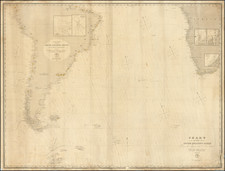
![(South Atlantic) Nieuwe Wassende Graadige Pas-kaart van de Kust van Guinea en Brasilia strekkende van Cap Verde tot de Cap de Bon-Esperance en Verders van Rio de Berbice tot Rio de la Plata. [New Increasing Latitude Sea Chart of the Coast of Guinea and Brazil stretching from Cape Verde to the Cape of Good Hope and Further from the Berbice River to the Rio de la Plata.]](https://storage.googleapis.com/raremaps/img/small/99819.jpg)