|
||

|

|
|

|
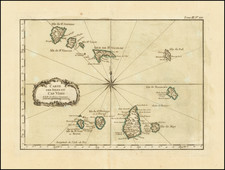
La Guinea Occidentale, engraved by G.Pitteri and published by Antonio Zatta in Venice in 1784, offers a detailed depiction of West Africa. Covering regions from C. Bianco d'Arguin and Caragol to the Gold Coast, the map is a significant record of the region's geography in the late 18th century.
During the 1700s, European engagement with Africa was characterized by increased trade and exploration activities. West Africa, known by its various "Coasts", was a region of particular interest due to its trade potential. This map, showcasing regions such as the Cape Verde Islands and the Senegalese coast, underscores the importance of maritime routes and coastal points in the context of European-African interactions.
Included in Zatta's Atlante Novissimo, the map reflects the prevailing European cartographic standards of the 18th century. The atlas, while decorative in nature, serves as a representation of the era's emphasis on combining visual appeal with geographical accuracy.
Antonio Zatta (fl. 1757-1797) was a prominent Italian editor, cartographer, and publisher. Little is known about his life beyond his many surviving published works. It is possible that he was born as early as 1722 and lived as late as 1804. He lived in Venice and his work flourished between 1757 and 1797. He is best known for his atlas, Atlante Novissimo (1779-1785), and for his prolific output of prints and books that were both precisely made and aesthetically pleasing. Zatta clearly had a large network from which to draw information; this is how he was able to publish the first glimpse of the islands visited by Captain Cook in the Atlante Novissimo. Zatta also published books of plays and architecture.
![[Belgian Congo - Katanga ]](https://storage.googleapis.com/raremaps/img/small/99902.jpg)