The item illustrated and described below is sold, but we
have another example in stock. To view the example which
is currently being offered for sale, click the
"View Details" button below.
![South Africa [Map Your Holiday in South Africa] By Art Maps Pty Ltd / South African Tourist Corporation](https://storage.googleapis.com/raremaps/img/small/96622.jpg)
1950 Art Maps Pty Ltd / South African Tourist Corporation
$ 395.00


|
||

|

|
|

|
Stock# 97637
Description
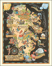
Attractive pictorial map of South Africa from the middle of the 20th century, featuring large illustrations of surfers, flora and fauna, views of Victoria Falls and other local landmarks, etc.
The map features the routes of S.A. Airways, railways, national roads, international and provincial boundaries, etc.
Condition Description
Folding map printed on both sides.