|
||

|

|
|

|
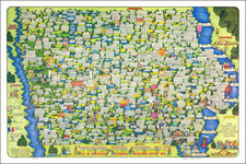
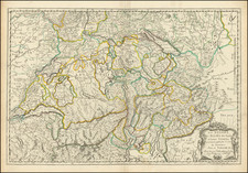
Pictorial map of Switzerland and environs, published by the Swiss Federal Railroads Commission, Berne 1933.
Includes a lovely composite vignette of Swiss topography on the verso.
The map illustrates the web of available railroad lines radiating out from Switzerland and into the neighboring countries, with dozens of whimsical images and vignettes.
Presumably aimed at promoting tourism in the UK and English speaking countries.
Rumsey identifies P. Gauchet as the artist, noting:
Originally published in 1931, showing the international railway connections of Switzerland. . . illustration of Swiss scenery and portrait of William at upper right corner by P. Gauchet from the earlier edition on recto,
On verso text: "The Land of Contrasts", information on Railway Tickets and explanation on the railway map. Map surrounded by humorous characters, sailing ships. . . shows Switzerland at the center of a network of railways from southern England at the upper left to Venice and Florence at the lower right, also showing major cities and towns. . . .