


|
||

|

|
|

|
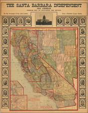
Rare Santa Barabara Independent Map -- Showd Congressional Districts and Portraits of California Governors
Rare separately published map of California and Nevada, published by the Santa Barbara Independent.
This unusual color printed map provides a highly detailed image of Califoria and Nevada, following the 1910 Census. Published by the The Santa Barbara Independent, the map was likely issued as and advertising or promotional item for display in busineesses around the Central Coast of California.
The map is remarkably detailed, including cities, towns, roads, railroads, rivers, topographical features and other details, with relative population of cities keyed to different symbols. Key features include an elaborate system of railroads, distinguished by numerals indicating distances, and varying font weights to represent towns based on their population size. Two large insets at the bottom left show close up images of the Bay Area and the Los Angeles Basin, allowing for a closer look at the electric street car lines in the more densely populated regions.
The map is ringed with portraits of California's Governors from 1849 to 1911 and a view of the Capital Building.
The level of detail, such as the use of red lines to depict electric lines and canals, is impressive. Additionally, the demarcation of congressional districts, national parks, forests, and Indian reservations is exceptional.
Rarity
This map is very rare. This is the first example we have ever seen.
![[ Idaho Below Montana ] Verein-Staaten am Stillen Ocean… [inset of San Francisco Bay] [Unusual Idaho & California configurations]](https://storage.googleapis.com/raremaps/img/small/99297.jpg)
![[Austins Colony] Mexico & Guatemala](https://storage.googleapis.com/raremaps/img/small/94054.jpg)
![[ Alaska / Cabo San Lucas / San Blas / Chile ] Views of Headlands and Islands on the Coasts of North West and South America](https://storage.googleapis.com/raremaps/img/small/88077.jpg)