|
||

|

|
|

|
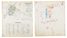
Detailed Mapping of Douglas, Arizona in the 1920s
Including Unincorporated Mexican Neighborhood of Pirtleville
A fire insurance atlas of Douglas and Pirtleville, Arizona, produced by the Sanborn Map Company in December 1929. This atlas offers perhaps the most detailed record of the built environment of the burgeoning Arizona border town for the time. Comprising 46 unbound sheets with hand-colored maps, the atlas was originally made as a specialized tool for insurance company underwriters in determining the degree of fire risk associated with any property shown therein. Today it is an unrivaled visual record of Douglas's urban landscape in the 1920s, when the town had a population of 12,500.
Executed with a scale 50 feet to an inch, the atlas shows every building in Douglas and Pirtleville, with block-by-block, street-by-street, structure-by-structure, color-coded representations. Use of each structure is given: dwelling, grocery, storage, lumber yard, movie theater, church, hardware, water tower, etc., often recording the name of the individual business owner. Color coding denotes building material. Notably there were a large number of adobe structures in Douglas, including tenements, individual dwellings, and a Mexican movie theatre.
In the 1920s, Douglas, Arizona served as a bustling border town situated adjacent to Agua Prieta, Mexico. During this period, it was known for its vibrant economic activities, which included mining and cattle ranching, as well as its role as a significant port of entry between the United States and Mexico. The town's proximity to the Mexican border made it a focal point for trade, migration, and cultural exchange, but it also led to complexities related to law enforcement and border security. The decade was marked by the dynamics of the Mexican Revolution, Prohibition, and the burgeoning copper mining industry (notably through the operations of the Phelps-Dodge Co.), all of which had substantial impacts on Douglas and its community.
Pirtleville: an Island of Mexican American Culture in Douglas
According to historian Josiah Heyman, the unincorporated community of Pirtleville (covered in the present atlas), just outside the city limits of Douglas, grew into an into an independent community characterized by Mexican-owned businesses and celebrations of Mexican Fiestas Patrias. A Mexican mutual-aide society, the Sociedad Mutualista de Obreros Mexicanos, was established in 1923, to self assist Mexican workers from the smelters, particularly when illness or injury struck:
In a sea of discrimination, Pirtleville was an island of cultural and social self-expression for Mexican Americans, echoes of which can still be heard today... Pirtleville was popular with Mexican Americans for three reasons. Lying just south of the smelters, it was much easier to walk to work from there than from Douglas. Land was inexpensive. In Pirtleville a house lot cost about fifty dollars whereas in Douglas, one could cost two hundred dollars or more... Mexican Americans were more often homeowners in Pirtleville and renters in Douglas.... Pirtleville was the only place where Hispanics and non-Hispanics met on a relatively equal footing. Pirtleville supported a number of Mexican businesses....there were roughly twelve small stores in Pirtleville around 1920, all of them owned by Mexicans... Ramon Jordan's uncle Luis had a woodyard and a butcher shop... Although there were Mexican businesses inside Douglas, it appears that Pirtleville offered more opportunity for Mexican American businesses, possibly because it sheltered them from the large corporate and Jewish and Lebanese immigrant businesses of the city - Oral History of the Mexican American Community of Douglas, Arizona, 1901-1942, Journal of the Southwest, Vol. 35, No. 2 (Summer, 1993), page 195.
Here follows a selection of the structures and sites shown in the atlas:
- Apache Powder Co.
- Arizona Gypsum Plaster Co.
- Ave. A. Grammar School
- Calumet & Arizona Mining Co. Reduction Works, Copper Smelter (page 46, entire sheet)
- Clawson Grammar School
- Douglas Country Club House
- Douglas Daily Dispatch
- Hotel Gadsden
- Latter Day Saints Church
- Levy Bros. Department Store
- Mexican Methodist Church
- Mexican Presbyterian Church
- Mexican Theatre & Movies (Adobe)
- Phelps-Dodge Corp. Copper Queen Branch Reduction Works (page 45, entire sheet)
- Southern Pacific Railroad Shop & Round House
- St. Bernard's Church
- Sunnyside School
- Texas Company
- Twelfth Street Grammar School
Rarity
The Douglas, Arizona Sanborn atlas is rare in the market. OCLC locates editions of 1904, 1909, 1914, and 1929 at the University of Arizona. We also note another example of the 1929 edition held at California State Northridge. The Library of Congress has digitized editions of 1904, 1924, 1914, 1929, and 1929 (updated to 1947).
The Sanborn Map Company, founded in the 1860s by Daniel Alfred Sanborn, is a renowned cartographic institution primarily recognized for its unparalleled fire insurance atlases. These atlases emerged as indispensable tools during the late 19th and early 20th centuries, portraying the evolution of urban America with unprecedented detail and precision. Charting both burgeoning metropolises and smaller municipalities, Sanborn's fire insurance maps provide a unique and illuminating perspective on the physical, economic, and social transformation of the nation during a period of intense urbanization and industrialization.
During the latter half of the 19th century, the United States witnessed an acceleration in urban growth. This shift from rural to urban living, bolstered by the advent of the Industrial Revolution, generated densely populated areas with a diverse array of architectural styles, materials, and infrastructure. In this context, the need for comprehensive maps that could illustrate the specifics of the built urban fabric became paramount, especially for insurance companies seeking to assess the risks associated with insuring individual properties. The Sanborn Map Company responded to this demand, creating elaborate maps that identified building materials, the purpose of structures, and even features like fire walls and sprinkler systems.
A standout feature of Sanborn's maps was their color-coding system, which allowed for a swift and clear differentiation between building materials—whether wood, brick, iron, or otherwise. This system, paired with the company's legends -- detailing everything from the width of streets to the locations of hydrants -- made these atlases an invaluable resource for insurance underwriters. By the turn of the 20th century, Sanborn maps covered thousands of cities and towns across the United States.
Beyond their utility to the insurance industry, the atlases produced by the Sanborn Map Company have, over time, become a treasured resource for historians, urban planners, preservationists, and environmental researchers. These maps have also been pivotal in brownfield research, shedding light on past industrial activities and potential contamination sites. They offer a window into the past, capturing the architectural, infrastructural, and environmental trends of various eras, and revealing the intricacies of a city's development. The very design of streets, the evolution of residential and commercial areas, and the rise and decline of certain industries can be traced through these maps.
Around 1960, Warren Buffett, then a burgeoning value investor, took a significant position in Sanborn Map Co., sinking 35% of his partnership's money into the company. Buffett was drawn to Sanborn's extensive map business, which he described as a virtual monopoly, as well as the company's valuable investment portfolio. While the cartographic aspect of Sanborn's business was diminishing in profitability due to technological advances introduced by competitors, Buffett recognized that the informational content of the maps had not been updated to electronic access, and was thus an undervalued asset for the company. His investment in Sanborn Map Co. is often presented as Case Study No. 1 in overviews of his value-oriented investment philosophy, which emphasized undervalued assets.
In sum, the Sanborn Map Company's fire insurance atlases are not merely maps; they are intricate tapestries of American urban history, detailing the nation's progression from the late 19th to the 20th century. Through their detailed renderings, these maps continue to serve as invaluable chronicles of the United States' urban transformation during a pivotal era.
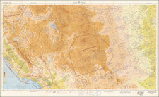

![[Report and] Map of an Exploring Expedition to The Rocky Mountains in the Years 1842 and to Oregon & North California in the Years 1843-44 By Brevet Capt. J. C. Fremont of the Corps of Topographical Engineers . . .](https://storage.googleapis.com/raremaps/img/small/88488.jpg)