


|
||

|

|
|

|
Chandler, Arizona in 1929
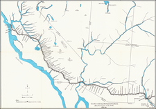
A fire insurance atlas of Chandler, Maricopa County, Arizona, produced by the Sanborn Map Company in May 1924 and updated in June 1929. This atlas offers a detailed record of the built environment of the burgeoning Arizona town near Phoenix. Comprising 7 unbound sheets with hand-colored maps, the atlas was originally made as a specialized tool for insurance company underwriters in determining the degree of fire risk associated with any property shown therein. Today it is an unrivaled visual record of Chandler's urban landscape for the time.
Executed with a scale 50 feet to an inch, the atlas shows every building in Chandler with block-by-block, street-by-street, structure-by-structure color-coded representations. Use of each structure is given: dwelling, grocery, storage, lumber yard, movie theater, church, hardware, water tower, etc., often recording the name of the individual business owner. Color coding denotes building material. Interestingly, several of the buildings are noted as being of adobe construction.
In the 1920s, Chandler, Arizona, was a fledgling agricultural community primarily centered around cotton farming. Founded in 1912 by Dr. A. J. Chandler, for whom the town was named, Chandler was designed as a planned community with modern irrigation techniques that enabled productive agriculture. The town was connected to broader markets through its access to key transportation routes, including the Southern Pacific Railroad. While it was still a small community at this time, the '20s set the foundation for Chandler's future growth, as it began attracting residents and local businesses, further solidifying its role as an emerging urban center in the region.
Notable structures shown include the Hotel San Marcos and the Hotel Suhuaro. The Suhuaro (or Suhwaro) was designed by a noted Arizona architectural firm Creighton & McDonald. Creighton designed many private residences, including the Peterson House in Tempe and Old Main on the Arizona State University campus.
Here follows a selection of the structures and sites shown in the atlas:
- American Legion Boxing Arena
- Attaway & Campbell's Cotton Gin
- Chandler Ginning Co. Long Staple Cotton
- Chandler Municipal Water Works
- "Cheap Mexican Shacks" (along S. Colorado, south of E. Boston)
- Hotel San Marcos
- Hotel San Marcos Bungalows (arranged around a pond)
- Hotel Suhuaro (incorporating a public library and the Chamber of Commerce)
- L. D. S. Church
- S. A. Gerrard Co. Fruits & Vegetables
- San Marcos Employees Cottages
Rarity
The Chandler Sanborn atlas is very rare in the market. Our 1924 (updated to June 1929) edition is almost certainly the unique surviving exemplar of the 1929 update.
OCLC lists only a single example of an unidentified edition of the Chandler Sanborn atlas, that at the University of Arizona. We also note California State Northridge's holdings of the 1915 and a 1924 base edition.
The Library of Congress has digitized their May 1915 edition, but as of this writing they have not made their base 1924 and 1924 (updated to 1932) editions available online.
The Sanborn Map Company, founded in the 1860s by Daniel Alfred Sanborn, is a renowned cartographic institution primarily recognized for its unparalleled fire insurance atlases. These atlases emerged as indispensable tools during the late 19th and early 20th centuries, portraying the evolution of urban America with unprecedented detail and precision. Charting both burgeoning metropolises and smaller municipalities, Sanborn's fire insurance maps provide a unique and illuminating perspective on the physical, economic, and social transformation of the nation during a period of intense urbanization and industrialization.
During the latter half of the 19th century, the United States witnessed an acceleration in urban growth. This shift from rural to urban living, bolstered by the advent of the Industrial Revolution, generated densely populated areas with a diverse array of architectural styles, materials, and infrastructure. In this context, the need for comprehensive maps that could illustrate the specifics of the built urban fabric became paramount, especially for insurance companies seeking to assess the risks associated with insuring individual properties. The Sanborn Map Company responded to this demand, creating elaborate maps that identified building materials, the purpose of structures, and even features like fire walls and sprinkler systems.
A standout feature of Sanborn's maps was their color-coding system, which allowed for a swift and clear differentiation between building materials—whether wood, brick, iron, or otherwise. This system, paired with the company's legends -- detailing everything from the width of streets to the locations of hydrants -- made these atlases an invaluable resource for insurance underwriters. By the turn of the 20th century, Sanborn maps covered thousands of cities and towns across the United States.
Beyond their utility to the insurance industry, the atlases produced by the Sanborn Map Company have, over time, become a treasured resource for historians, urban planners, preservationists, and environmental researchers. These maps have also been pivotal in brownfield research, shedding light on past industrial activities and potential contamination sites. They offer a window into the past, capturing the architectural, infrastructural, and environmental trends of various eras, and revealing the intricacies of a city's development. The very design of streets, the evolution of residential and commercial areas, and the rise and decline of certain industries can be traced through these maps.
Around 1960, Warren Buffett, then a burgeoning value investor, took a significant position in Sanborn Map Co., sinking 35% of his partnership's money into the company. Buffett was drawn to Sanborn's extensive map business, which he described as a virtual monopoly, as well as the company's valuable investment portfolio. While the cartographic aspect of Sanborn's business was diminishing in profitability due to technological advances introduced by competitors, Buffett recognized that the informational content of the maps had not been updated to electronic access, and was thus an undervalued asset for the company. His investment in Sanborn Map Co. is often presented as Case Study No. 1 in overviews of his value-oriented investment philosophy, which emphasized undervalued assets.
In sum, the Sanborn Map Company's fire insurance atlases are not merely maps; they are intricate tapestries of American urban history, detailing the nation's progression from the late 19th to the 20th century. Through their detailed renderings, these maps continue to serve as invaluable chronicles of the United States' urban transformation during a pivotal era.
![[Composite Atlas of the World]](https://storage.googleapis.com/raremaps/img/small/103160.jpg)
![(Arizona Native American Photograph) [Original CDV of a Pima or Apache Child]](https://storage.googleapis.com/raremaps/img/small/93107.jpg)
![[ Ethnographic Thematic Atlas - Poland, Lithuania, Ukraine, etc. ] Völker-Verteilung in West-Russland (Distribution of Peoples in Western-Russia)](https://storage.googleapis.com/raremaps/img/small/94045.jpg)