


|
||

|

|
|

|
Glendale, Arizona in 1931
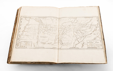
A fire insurance atlas of Glendale, Arizona, produced by the Sanborn Map Company in 1924, and updated to May 1931. The atlas comprises 17 unbound sheets with hand-colored maps originally intended for the use of insurance company underwriters in determining the degree of fire risk associated with any property shown therein. Today it is an unrivaled record of Glendale's urban and architectural landscape at the time, before its explosive suburban growth.
Executed with a scale 50 feet to an inch, every structure in Glendale is accurately shown with block-by-block, street-by-street, structure-by-structure representations. Use of every structure is given: dwelling, grocery, storage, lumber yard, church, hardware, water tower, etc., often recording the name of the individual business owner noted. Color coding denotes building material.
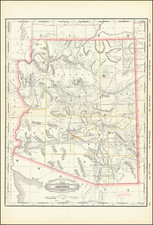
In the 1920s, Glendale, located near Phoenix, in Maricopa County, was a small Arizona agricultural community primarily focused on cotton farming thanks to its participation in the Salt River Project, an ambitious water reclamation initiative. The city served as a trading center for the surrounding farms and ranches. It had a modest downtown area featuring essential businesses like general stores, banks, and a post office. The Beet Sugar Factory in Glendale was another significant employer and economic pillar, processing sugar beets into refined sugar. Although it was a far cry from the bustling suburban city it has become, the 1920s saw Glendale laying the foundations for future growth.
Here follows a selection of the structures in the atlas:
- Arizona Cotton Oil Co. Inc.
- Associated Dairy Products Co., Ice Factory and Creamery
- R. C. Davies Warehouse, formerly Western Sugar & Land Co.'s Beet & Cane Sugar Factory
- Glendale Grade School
- Glendale Union High School
- J. D. Halsted Lumber Co.
- Mutual Cotton & Oil Co.
- Roman Catholic Church (Mexican)
- Western Sugar & Land Co.
For nearly a century (from 1867 to 1961), Sanborn Map Company produced their fire insurance maps for nearly all U.S. cities. Ron Tyler (Prints of the West, pages 153-55) describes the fire insurance maps as a successor to the bird’s-eye view in documenting the growth of towns and cities. The present Glendale, Arizona atlas bears out Tyler's assertion.
Rarity
The Glendale, Arizona Sanborn atlas is very rare in any edition. Our example is almost certainly the unique exemplar of the 1924 edition with May 1931 updates.
OCLC locates a single unidentified edition at the University of Arizona. The Library of Congress has digitized a 1915 edition, but as of this writing they have not made their two 1924 examples available online (a base 1924 edition, and a November 1948 updated example, respectively). No holdings of the Glendale, Arizona atlas reported in extensive Sanborn map collection at California State Northridge.
The Sanborn Map Company, founded in the 1860s by Daniel Alfred Sanborn, is a renowned cartographic institution primarily recognized for its unparalleled fire insurance atlases. These atlases emerged as indispensable tools during the late 19th and early 20th centuries, portraying the evolution of urban America with unprecedented detail and precision. Charting both burgeoning metropolises and smaller municipalities, Sanborn's fire insurance maps provide a unique and illuminating perspective on the physical, economic, and social transformation of the nation during a period of intense urbanization and industrialization.
During the latter half of the 19th century, the United States witnessed an acceleration in urban growth. This shift from rural to urban living, bolstered by the advent of the Industrial Revolution, generated densely populated areas with a diverse array of architectural styles, materials, and infrastructure. In this context, the need for comprehensive maps that could illustrate the specifics of the built urban fabric became paramount, especially for insurance companies seeking to assess the risks associated with insuring individual properties. The Sanborn Map Company responded to this demand, creating elaborate maps that identified building materials, the purpose of structures, and even features like fire walls and sprinkler systems.
A standout feature of Sanborn's maps was their color-coding system, which allowed for a swift and clear differentiation between building materials—whether wood, brick, iron, or otherwise. This system, paired with the company's legends -- detailing everything from the width of streets to the locations of hydrants -- made these atlases an invaluable resource for insurance underwriters. By the turn of the 20th century, Sanborn maps covered thousands of cities and towns across the United States.
Beyond their utility to the insurance industry, the atlases produced by the Sanborn Map Company have, over time, become a treasured resource for historians, urban planners, preservationists, and environmental researchers. These maps have also been pivotal in brownfield research, shedding light on past industrial activities and potential contamination sites. They offer a window into the past, capturing the architectural, infrastructural, and environmental trends of various eras, and revealing the intricacies of a city's development. The very design of streets, the evolution of residential and commercial areas, and the rise and decline of certain industries can be traced through these maps.
Around 1960, Warren Buffett, then a burgeoning value investor, took a significant position in Sanborn Map Co., sinking 35% of his partnership's money into the company. Buffett was drawn to Sanborn's extensive map business, which he described as a virtual monopoly, as well as the company's valuable investment portfolio. While the cartographic aspect of Sanborn's business was diminishing in profitability due to technological advances introduced by competitors, Buffett recognized that the informational content of the maps had not been updated to electronic access, and was thus an undervalued asset for the company. His investment in Sanborn Map Co. is often presented as Case Study No. 1 in overviews of his value-oriented investment philosophy, which emphasized undervalued assets.
In sum, the Sanborn Map Company's fire insurance atlases are not merely maps; they are intricate tapestries of American urban history, detailing the nation's progression from the late 19th to the 20th century. Through their detailed renderings, these maps continue to serve as invaluable chronicles of the United States' urban transformation during a pivotal era.
![[ Southern California Water Explorations ] Topographical Sketch showing the Outward and Inward Route of A Party, while examining the practicability of a Diversion of the Colorado River for Purposes of Irrigation under the Command of 1st Lieut. Eric Bergland Corps of Engineers, U.S. Army 1875](https://storage.googleapis.com/raremaps/img/small/98208.jpg)
![[ London ] An Exact Survey of the City's of London Westminster ye Borough of Southwark and the Country Near Ten Miles Round Begun In 1741 & Ended in 1745 By John Rocque Land Surveyor & Engrau'd By Richard Parr / A New and Accurate Survey Of the Cities of London and Westminster The Borough of Southwark with The Country about it for nineteen Miles in Length and thirteen in Depth . . .](https://storage.googleapis.com/raremaps/img/small/96431.jpg)

![Uranometria, omnium asterismorum continens schemata, nova methodo delineata, aeris laminis expressa. [bound with:] Explicatio characterum aeneis uranometrias imaginum, tabulis, insculptorum, addita, & commodiore hac forma tertium redintegrata.](https://storage.googleapis.com/raremaps/img/small/70736.jpg)