|
||

|

|
|

|
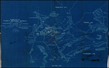
Casa Grande, Arizona in 1931
A fire insurance atlas of Casa Grande, Pinal County, Arizona, produced by the Sanborn Map Company in April 1922 and updated in May 1931. This atlas offers a detailed record of the built environment of this small Arizona town, located just south of the Gila River Indian Reservation, between Phoenix and Tucson. Comprising 5 unbound sheets with hand-colored maps, the atlas was originally made as a specialized tool for insurance company underwriters in determining the degree of fire risk associated with any property shown therein. Today it is an unrivaled visual record of Casa Grande's urban landscape for the time.
Executed with a scale 50 feet to an inch, every building in Casa Grande is accurately shown with block-by-block, street-by-street, structure-by-structure representations. Use of each structure is given: dwelling, grocery, storage, lumber yard, movie theater, church, hardware, water tower, etc., often recording the name of the individual business owner. Color coding denotes building material. Interestingly, several of the buildings are noted as being of adobe construction.
During the 1920s, Casa Grande was primarily an agricultural community, with cotton farming as one of its major economic activities. The Southern Pacific Railroad, which passed through the town, played a significant role in transporting agricultural goods, thereby linking Casa Grande to broader markets. The period also saw the establishment of some local businesses (attested by the numerous pasted-on updates in the present Sanborn atlas), and the town served as a regional hub for commerce and social activities. During WWII, a Japanese-American relocation camp was set up outside of Casa Grande, the Gila River War Relocation Center. Despite experiencing modest growth through the years with the introduction of new businesses, Casa Grande's economic backbone remained the agricultural sector.
Here follows a selection of the structures and sites shown in the atlas:
- Arizona State Armory
- Casa Grande Dispatch Job Printing
- Casa Grande Farmer's Association
- Casa Grande Union High School
- D. Halsted Lumber Co.
- H. Swanzy Lumber Yard
- O'Malley Lumber
- Pinal Creamery Co.
- Sacaton Hotel
- San Carlos Hotel
- Southern Pacific Railroad Depot
- Valley Bottling Works
Rarity
The Casa Grande Sanborn atlas is rare. Our example is almost certainly the unique survivor of the 1922 edition with May 1931 updates.
OCLC locates a single unidentified edition of the Casa Grande atlas, that at the University of Arizona. California State University Northridge lists holding a 1922 base edition. The Library of Congress has digitized their holdings of 1890, 1898, 1909, 1914, 1922, and a 1922 edition updated to 1940 (but not the May 1931 update).
The Sanborn Map Company, founded in the 1860s by Daniel Alfred Sanborn, is a renowned cartographic institution primarily recognized for its unparalleled fire insurance atlases. These atlases emerged as indispensable tools during the late 19th and early 20th centuries, portraying the evolution of urban America with unprecedented detail and precision. Charting both burgeoning metropolises and smaller municipalities, Sanborn's fire insurance maps provide a unique and illuminating perspective on the physical, economic, and social transformation of the nation during a period of intense urbanization and industrialization.
During the latter half of the 19th century, the United States witnessed an acceleration in urban growth. This shift from rural to urban living, bolstered by the advent of the Industrial Revolution, generated densely populated areas with a diverse array of architectural styles, materials, and infrastructure. In this context, the need for comprehensive maps that could illustrate the specifics of the built urban fabric became paramount, especially for insurance companies seeking to assess the risks associated with insuring individual properties. The Sanborn Map Company responded to this demand, creating elaborate maps that identified building materials, the purpose of structures, and even features like fire walls and sprinkler systems.
A standout feature of Sanborn's maps was their color-coding system, which allowed for a swift and clear differentiation between building materials—whether wood, brick, iron, or otherwise. This system, paired with the company's legends -- detailing everything from the width of streets to the locations of hydrants -- made these atlases an invaluable resource for insurance underwriters. By the turn of the 20th century, Sanborn maps covered thousands of cities and towns across the United States.
Beyond their utility to the insurance industry, the atlases produced by the Sanborn Map Company have, over time, become a treasured resource for historians, urban planners, preservationists, and environmental researchers. These maps have also been pivotal in brownfield research, shedding light on past industrial activities and potential contamination sites. They offer a window into the past, capturing the architectural, infrastructural, and environmental trends of various eras, and revealing the intricacies of a city's development. The very design of streets, the evolution of residential and commercial areas, and the rise and decline of certain industries can be traced through these maps.
Around 1960, Warren Buffett, then a burgeoning value investor, took a significant position in Sanborn Map Co., sinking 35% of his partnership's money into the company. Buffett was drawn to Sanborn's extensive map business, which he described as a virtual monopoly, as well as the company's valuable investment portfolio. While the cartographic aspect of Sanborn's business was diminishing in profitability due to technological advances introduced by competitors, Buffett recognized that the informational content of the maps had not been updated to electronic access, and was thus an undervalued asset for the company. His investment in Sanborn Map Co. is often presented as Case Study No. 1 in overviews of his value-oriented investment philosophy, which emphasized undervalued assets.
In sum, the Sanborn Map Company's fire insurance atlases are not merely maps; they are intricate tapestries of American urban history, detailing the nation's progression from the late 19th to the 20th century. Through their detailed renderings, these maps continue to serve as invaluable chronicles of the United States' urban transformation during a pivotal era.


![The English Pilot. Describing the West-India Navigation, from Hudson's Bay to the River Amazones. [Fourth Book]](https://storage.googleapis.com/raremaps/img/small/71190.jpg)
![(Ecclesiastical Atlas) Chorographica Descriptio Provinciarum et Conventuum Fratrum Minorum Francisci Capucinorum [Chorographic Description of the Provinces and Convents of the Friars Minor of Francis Capuchin. . . ]](https://storage.googleapis.com/raremaps/img/small/93059.jpg)