


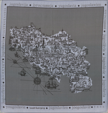
|
||

|

|
|

|
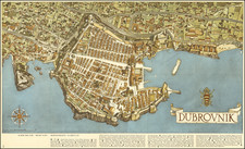
This bird's eye view, created in 1962 by architect Olivera Bravačić, presents a vibrant depiction of Dubrovnik, Croatia, coinciding with the inauguration of its airport, which marked a new era of accessibility and growth for the famed summer resort.
In the context of the 1960s, Dubrovnik was undergoing significant transformations, evolving from an ancient maritime city into a modern tourist hub. The opening of the airport represented a pivotal moment, overcoming the city's historical isolation imposed by its challenging terrain and limited access routes. This map captures the physical beauty of Dubrovnik and symbolizes the city's transition into a more connected and bustling Mediterranean destination.
Olivera Bravačić's representation is detailed and informative, offering a panoramic view of the city's topography, architecture, and cultural sites. The map is further enriched by a legend in five languages, pinpointing 27 notable locations including hotels, villas, and restaurants, along with the newly constructed path to the airport.
![(Austria) Charte der Österreichischen Monarchie, nach den letzten Friedensschlüssen berichtigt. [Map of the Austrian Monarchy, corrected according to the latest peace treaties.]](https://storage.googleapis.com/raremaps/img/small/102892.jpg)
![Hungaria Ungarn [Hungary, Slovakia, Northern Croatia and Northern Serbia]](https://storage.googleapis.com/raremaps/img/small/76437mp2.jpg)