|
||

|

|
|

|
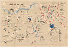
Small, but ours!
The Territorial Results of the Munich Agreement.
Documenting the Second Czechoslovak Republic, Extant for Only 169 Days.
This map, titled Malá, ale naše, translated as "Small, but ours," stands as a poignant testament to a nation's resilience in the face of profound territorial and political challenges. This map highlights the Second Czechoslovak Republic's boundaries, emphasizing regions like Bohemia (Čechy), Moravia and Silesia (Morava a Slezsko), Slovakia (Slovensko), and Subcarpathian Rus (Podkarp. Rus). The delineated territories and populations reflect a country grappling with significant territorial and population losses.
The map reveals the Czechoslovak Republic's loss of 41,596 km² of land to neighboring countries: 28,680 km² to Germany, 11,830 km² to Hungary, and 1,086 km² to Poland. This shift impacted 4,922,440 people, with Germany absorbing 3,653,292 individuals, Hungary incorporating 1,027,450, and Poland taking in 241,698. Despite these losses, the remaining territories displayed steadfast populations: Bohemia with 4,472,354 inhabitants, Moravia and Silesia with 2,332,522, Slovakia with 2,450,096, and Subcarpathian Rus with 552,124.
The accompanying text on the map underscores the Czech spirit of resilience and self-reliance. The Czechoslovak people, despite retaining a reduced portion of their original land and population, maintained unwavering faith in themselves, their industry, and their identity. The narrative urges national solidarity, economic self-reliance, and prioritization of domestic over foreign products.
Historical context offers deeper insight into the map's significance. The territorial losses represented align with the period of the Second Czechoslovak Republic, a short-lived era that endured for only 169 days. This republic emerged in the aftermath of the Munich Agreement in 1938 when Czechoslovakia was coerced into ceding territory to Germany. Thus, the map stands as visual documentation of a nation's transient geopolitical state during this tumultuous period.
While the existence of the Second Czechoslovak Republic was fleeting, its impact persisted. The map "Malá, ale naše" captures a moment in history when a reduced nation remained anchored by its rich heritage and unwavering spirit.
The Second Czechoslovak Republic
The Second Czechoslovak Republic existed briefly from October 1938 to March 1939, following the Munich Agreement wherein Nazi Germany, Italy, France, and the United Kingdom permitted the annexation of the Czechoslovak border regions, known as the Sudetenland, by Germany. This territorial concession, made without Czechoslovakia's input, crippled the country both militarily and economically. During its short existence, the republic was marked by political instability, pressure from neighboring countries, and an altered state identity, eventually culminating in the occupation of Czech lands by Nazi Germany and the emergence of the Slovak State in March 1939.
![[Prague] Panorama Kralovske Prahy](https://storage.googleapis.com/raremaps/img/small/89611.jpg)