|
||

|

|
|

|
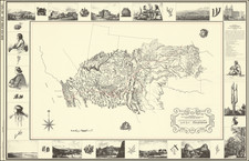
Detailed Snapshot of Mesa, Arizona's Built Enviornment in 1926
Mesa, Maricopa Co. Arizona, a fire insurance atlas published by the Sanborn Map Company in April 1923, updated to June 1926 in the present example, provides a detailed representation of Mesa's buildings and civic amenities during the early 20th century.
In the 1920s, Mesa experienced significant growth and transformation. As part of the greater Phoenix area, Mesa saw its population expand during this decade, largely due to the increased availability of water from projects like the Roosevelt Dam, completed in 1911. This infrastructure allowed for greater agricultural development, with the region becoming a hub for cotton, citrus, and alfalfa farming. The 1920s also witnessed an expansion in transportation connectivity. The Southern Pacific Railroad had reached Mesa in the late 19th century, and the 1920s brought improved roadways, fostering greater connectivity within the state and with neighboring states. Despite the national economic challenges of the Great Depression starting in 1929, the groundwork laid in the 1920s positioned Mesa to continue its growth and development in the decades that followed. Notably, Mesa already had at least half a dozen Mormon churches.
Produced by the Sanborn Map Company, known for their detailed fire insurance maps, the atlas provides a granular breakdown of Mesa's infrastructure, both municipal and private. It differentiates buildings based on construction materials — from frame to red brick to stone — and includes details on fire safety measures such as automatic sprinklers and fireproof constructions. Information about water facilities is precise, detailing the depth of wells, pump capacities, and the network of cast-iron mains.
A selection of the buildings and sites noted in the atlas here follows:
- Alhambra Hotel
- Mesa City Water Works
- Mesa Seed & Feed Co.
- Metsford Hotel
- Mormon L.D.S. Maricopa Stake Tabernacle
- Second Ward Chapel Church of Jesus Christ of L.D.S.
Additionally, the atlas highlights the city's fire department structure, resources, and fire alarm system. The inclusion of an electric Gamewell system and an air diaphone (located on the roof of the fire station) indicates the city's utilization of technology to bolster safety measures.
A methodical record of Mesa's urban layout and infrastructure in the early 20th century, shedding light on the city's growth trajectory, essential to understanding urban expansion and safety during that time.
Rarity
The Mesa, Arizona Sanborn atlas is extremely rare in the market. Our example is almost certainly a unique exemplar with 1926 updates. OCLC fails to locate a single example of any edition. California State Northridge, which boasts a massive collection of Sanborn atlases, does not list anything for Mesa, Arizona. The Library of Congress has digitized editions of 1898, 1901, 1911, and 1915. As of this writing, LC's 1923 edition holdings (none of which include updates to June 1926) have not been made available online as of this writing.
The Sanborn Map Company, founded in the 1860s by Daniel Alfred Sanborn, is a renowned cartographic institution primarily recognized for its unparalleled fire insurance atlases. These atlases emerged as indispensable tools during the late 19th and early 20th centuries, portraying the evolution of urban America with unprecedented detail and precision. Charting both burgeoning metropolises and smaller municipalities, Sanborn's fire insurance maps provide a unique and illuminating perspective on the physical, economic, and social transformation of the nation during a period of intense urbanization and industrialization.
During the latter half of the 19th century, the United States witnessed an acceleration in urban growth. This shift from rural to urban living, bolstered by the advent of the Industrial Revolution, generated densely populated areas with a diverse array of architectural styles, materials, and infrastructure. In this context, the need for comprehensive maps that could illustrate the specifics of the built urban fabric became paramount, especially for insurance companies seeking to assess the risks associated with insuring individual properties. The Sanborn Map Company responded to this demand, creating elaborate maps that identified building materials, the purpose of structures, and even features like fire walls and sprinkler systems.
A standout feature of Sanborn's maps was their color-coding system, which allowed for a swift and clear differentiation between building materials—whether wood, brick, iron, or otherwise. This system, paired with the company's legends -- detailing everything from the width of streets to the locations of hydrants -- made these atlases an invaluable resource for insurance underwriters. By the turn of the 20th century, Sanborn maps covered thousands of cities and towns across the United States.
Beyond their utility to the insurance industry, the atlases produced by the Sanborn Map Company have, over time, become a treasured resource for historians, urban planners, preservationists, and environmental researchers. These maps have also been pivotal in brownfield research, shedding light on past industrial activities and potential contamination sites. They offer a window into the past, capturing the architectural, infrastructural, and environmental trends of various eras, and revealing the intricacies of a city's development. The very design of streets, the evolution of residential and commercial areas, and the rise and decline of certain industries can be traced through these maps.
Around 1960, Warren Buffett, then a burgeoning value investor, took a significant position in Sanborn Map Co., sinking 35% of his partnership's money into the company. Buffett was drawn to Sanborn's extensive map business, which he described as a virtual monopoly, as well as the company's valuable investment portfolio. While the cartographic aspect of Sanborn's business was diminishing in profitability due to technological advances introduced by competitors, Buffett recognized that the informational content of the maps had not been updated to electronic access, and was thus an undervalued asset for the company. His investment in Sanborn Map Co. is often presented as Case Study No. 1 in overviews of his value-oriented investment philosophy, which emphasized undervalued assets.
In sum, the Sanborn Map Company's fire insurance atlases are not merely maps; they are intricate tapestries of American urban history, detailing the nation's progression from the late 19th to the 20th century. Through their detailed renderings, these maps continue to serve as invaluable chronicles of the United States' urban transformation during a pivotal era.
![Northeastern Arizona / Southern Utah / Northwestern New Mexico] Hopi Reservation / Navajo Reservation]](https://storage.googleapis.com/raremaps/img/small/72197dd.jpg)

![[ World Atlas -- Extra Illustrated ] The World Described; or, a New and Correct Sett of Maps: Shewing, the Kingdoms and States in all the known Parts of the Earth](https://storage.googleapis.com/raremaps/img/small/90102.jpg)