|
||

|

|
|

|
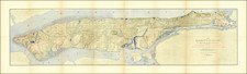
Manhattan Island at the Close of the Revolution, created by Townsend MacCoun in 1909, is a valuable representation of New York City in 1783. The map shows the layout of the American city and the Revolutionary fortifications in the region.
In 1783, the Revolutionary War ended, marking a transformative phase for the American colonies. This map captures Manhattan's urban and military landscape during that period. It highlights Revolutionary War fortifications and key landmarks like Columbia College, Bayard's Hill, and Bunker's Hill, providing a detailed portrayal of the city's organization and structures. These sites played crucial roles in engagements, planning, and troop placement, making Manhattan a centerpiece in the war. The map also shows city limits and streets, offering insights into the island's urban development.
Manhattan Island at the Close of the Revolution by Townsend MacCoun is a visually pleasing map and a snapshot of a city in transition, reflecting Manhattan's essence at the end of the Revolutionary War.
This is one of a series of maps of New York City that Mac Coun produced in 1909 as part of a methodical project to reconstruct the historical geography of the city.

![[Nolita -- Lower Manhattan] Map of Bayard's East Farm, Accurately Made From Old Maps, [not in Register's Office,] From Conveyances on Record from Nicholas Bayard, Sheriffs Sales, Lottery Lots &c. &c.](https://storage.googleapis.com/raremaps/img/small/61032.jpg)
![[ Florida / Georgia Coastline ] A Plan of Amelia Harbour and Bar, in East Florida, Surveyed by Jacob Blamey, Master of His Majesty's Schooner St. John](https://storage.googleapis.com/raremaps/img/small/38028.jpg)
![[Brooklyn] Manhattan Beach Estates - Map of Property situated in the Borough of Brooklyn](https://storage.googleapis.com/raremaps/img/small/80730.jpg)