|
||

|

|
|

|
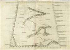
This interesting map, created for the Royal Geographic Society proceedings of January 9, 1865, showcases the region of Lake Nor-Zaisan (Lake Zaysan) in modern-day Kazakhstan, illustrating the findings from Russian explorer M.A. Abramof's recent expedition. The map is rich in detail, with renderings of mountains, rivers, and border. Additionally, the map highlights towns, landmarks, and historical sites, such as the "Ancient Stone Fortress," along the rivers and within the terrain.
While the map is in English, it is based on data from Russian expeditions, which aimed to chart the newly accessed land following the arrival of Russian Cossacks in the 18th century. Formerly administered by the Qing dynasty, this area was of significant interest to the Russian government. The map serves as a testament to the scientific rigor of Abramof's expedition, vividly portraying the rugged steppes of Kazakhstan and contributing to the geographical knowledge of the time.
M.A. Abramof's text from the Royal Geographic Society (RGS) Journal (not present here) provides valuable insights into the geography and culture surrounding Lake Nor Tsai-San (Lake Zaysan) in the Chinese Empire. Abramof describes the lake's physical characteristics, noting its size, depth, and the clarity and color of its waters. He also details the lake's ecological and economic importance, with abundant fish species like sturgeon, sterlet, and Nelma salmon supporting local fisheries. Furthermore, the text outlines the historical and cultural significance of the lake, highlighting its former name, "The Lake of Bells," given by the Mongols, and its current name, which translates to "noble" or "honourable" in the Kalmyk language. Overall, Abramof's text serves as a comprehensive and detailed account of Lake Nor Tsai-San, capturing its essence as a vital geographical, ecological, cultural, and economic entity.
![[ Black Sea ] The Euxine or Black Sea From The Russian Survey of 1826](https://storage.googleapis.com/raremaps/img/small/99954.jpg)
![Expedition Citroen Centre-Asie 3eme Mission G.-M. Haardt - L. Audouin-Dubreuil [with 2 official pamphlets for the route, etc.]](https://storage.googleapis.com/raremaps/img/small/63033.jpg)