|
||

|

|
|

|
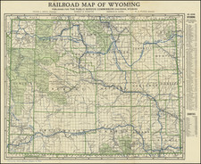
Stock# 97320
Description
Detailed map of the state of Wyoming. Railroads are illustrated in bold black, while highways are shown in bold blue. Towns, rivers, and forests are also depicted and named. Green shading is used to designate national parks/forests like Yellowstone or Medicine Bow Forest. The boundaries of counties are shown in green, and their names are bolded black. The righthand side contains a list of locations with a population of over 100. Below is a list of the counties of Wyoming and their population. Curiously, a note at the bottom says, "Principal Auto Roads Shown In Red," however, these seem to be nonexistent or drawn in blue. The map was done by the Clason Map Company, which is why it bears a striking resemblance to their 1919 Map of Wyoming.
Condition Description
Minor wear on folds. Expertly repaired tear on right-hand corner. Small tear just inside the upper neatline.
![Johnson's Nebraska, Dakota, Montana and Kansas [Rare Pre-Wyoming Territory configuration]](https://storage.googleapis.com/raremaps/img/small/94909.jpg)