|
||

|

|
|

|
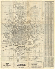
Prescott Yavapai Co. Arizona, produced by the Sanborn Map Company in 1924 and updated in June 1931, is a detailed fire insurance atlas of the important central Arizona city. This atlas not only documents the urban infrastructure of Prescott, including water facilities and prevailing winds, but also offers an analytical representation of the business structures and layouts of several industrial entities.
In the 1920s, Prescott was a bustling town with a rich history rooted in mining, ranching, and its former status as the Territorial Capital of Arizona. The decade was marked by the ongoing transition from the Old West to a more modernized era, reflecting the broader changes sweeping the United States. Downtown Prescott, centered around the Courthouse Plaza, remained a focal point of community activity, with the famous Whiskey Row still offering entertainment and a taste of the town's rowdier past.
The index sheet offers information on the city's fire department, segmented into four volunteer companies, each equipped with specialized apparatus for the era. Details on the fire alarm system, street layouts, electric lighting, and building infrastructure provide an accurate representation of Prescott's urban environment during this period.
Fire insurance maps are invaluable not only for their immediate practical use but also for their historical significance. They offer an often unparalleled snapshot of a town's urban development, infrastructural priorities, and the nature of businesses. This atlas, with its 23 sheets, gives insight into Prescott's careful planning and development trajectory in the early decades of the 20th century.
Rarity
Arizona Sanborn Insurance atlases from the early 20th-century are rare. OCLC locates only a single example of the 1924 Prescott Yavapai Atlas, at the University of Arizona, and California State Northridge lists an example of the 1924 edition in their index of Sanborn Atlases. The Library of Congress has digitized a 1924 base edition, but it does not incorporate the corrections through June 1931 included on the atlas offered here.
The Sanborn Map Company, founded in the 1860s by Daniel Alfred Sanborn, is a renowned cartographic institution primarily recognized for its unparalleled fire insurance atlases. These atlases emerged as indispensable tools during the late 19th and early 20th centuries, portraying the evolution of urban America with unprecedented detail and precision. Charting both burgeoning metropolises and smaller municipalities, Sanborn's fire insurance maps provide a unique and illuminating perspective on the physical, economic, and social transformation of the nation during a period of intense urbanization and industrialization.
During the latter half of the 19th century, the United States witnessed an acceleration in urban growth. This shift from rural to urban living, bolstered by the advent of the Industrial Revolution, generated densely populated areas with a diverse array of architectural styles, materials, and infrastructure. In this context, the need for comprehensive maps that could illustrate the specifics of the built urban fabric became paramount, especially for insurance companies seeking to assess the risks associated with insuring individual properties. The Sanborn Map Company responded to this demand, creating elaborate maps that identified building materials, the purpose of structures, and even features like fire walls and sprinkler systems.
A standout feature of Sanborn's maps was their color-coding system, which allowed for a swift and clear differentiation between building materials—whether wood, brick, iron, or otherwise. This system, paired with the company's legends -- detailing everything from the width of streets to the locations of hydrants -- made these atlases an invaluable resource for insurance underwriters. By the turn of the 20th century, Sanborn maps covered thousands of cities and towns across the United States.
Beyond their utility to the insurance industry, the atlases produced by the Sanborn Map Company have, over time, become a treasured resource for historians, urban planners, preservationists, and environmental researchers. These maps have also been pivotal in brownfield research, shedding light on past industrial activities and potential contamination sites. They offer a window into the past, capturing the architectural, infrastructural, and environmental trends of various eras, and revealing the intricacies of a city's development. The very design of streets, the evolution of residential and commercial areas, and the rise and decline of certain industries can be traced through these maps.
Around 1960, Warren Buffett, then a burgeoning value investor, took a significant position in Sanborn Map Co., sinking 35% of his partnership's money into the company. Buffett was drawn to Sanborn's extensive map business, which he described as a virtual monopoly, as well as the company's valuable investment portfolio. While the cartographic aspect of Sanborn's business was diminishing in profitability due to technological advances introduced by competitors, Buffett recognized that the informational content of the maps had not been updated to electronic access, and was thus an undervalued asset for the company. His investment in Sanborn Map Co. is often presented as Case Study No. 1 in overviews of his value-oriented investment philosophy, which emphasized undervalued assets.
In sum, the Sanborn Map Company's fire insurance atlases are not merely maps; they are intricate tapestries of American urban history, detailing the nation's progression from the late 19th to the 20th century. Through their detailed renderings, these maps continue to serve as invaluable chronicles of the United States' urban transformation during a pivotal era.