|
||

|

|
|

|
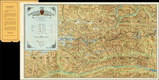
Rare pictorial map of the area around the campus of the University of California, Berkeley, published in about 1928 by Thomas Brothers and drawn by Virginia Tooker.
The map is centered on the Campanile, with California Memorial Stadium at the east, Channing Way in the south, Shattuck in the west, and Ridge Road in the north, illustrating the major landmarks and buildings on the campus at the end of the 1920s. Includes portraits of Henry Durant and Bishop George Berkeley.
The Fraternity and Sorority section is prominently shown below the stadium at the lower right and top left, with a vignette showing the "Channing Derby", a campus annual race in the 1920s and 1930s. Several streetcar lines are also shown, as is a reference to areas burned in the 1923 Berkeley fire.
The map is filled with clever vignettes and offering local humor, tributes to athletes (including Tennis greats Helen Wills and Helen Jacobs, both of whom were then students at UC Berkeley).
Rarity
The map is exceedingly rare. This is the second example we handled in over 30 years.