|
||

|

|
|

|
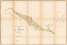
D.B. Cooke & Co's Great Western Railway Guide, published in Chicago in 1855, provides an illuminating depiction of the railway system spanning significant portions of the American Midwest. This map, printed by Middleton, Wallace & Co. Lithographers of Cincinnati, distinctly demarcates the rail-connected cities from Johnstown, Pennsylvania in the east to Iowa City in the west, and from Fondulac, Wisconsin in the north to Cairo, Illinois in the south. Beyond the mere illustration of geography, the guide meticulously differentiates between completed and incomplete railroads, offering readers a nuanced understanding of transportation development during this period.
D.B. Cooke & Co., based on Lake Street in Chicago, were not just publishers of this significant guide, but were also recognized as wholesale dealers in books, stationery, and pocket maps. Their contribution to the documentation and dissemination of key transportation data is evident through this work, serving as both an informative tool for contemporary users and a significant artifact for modern-day scholars and early railway enthusiasts.
This is the first edition. The map was reissued in 1856, 1860, and perhaps other years.
Chicago, Railroads, and the 1850s
By the mid-1850s, Chicago stood at a pivotal juncture, ready to transform into the rail hub of the United States. Its strategic location, aptly situated to serve as a crucial junction between the East and West, bolstered both commercial and passenger interests. The city was experiencing a surge in population; from a modest 4,000 in 1837, Chicago was home to nearly 90,000 people by 1860. This exponential growth was attributed to its burgeoning reputation as a premier trade and transportation center.
Two railroads, in particular, played instrumental roles in this rise. The Galena and Chicago Union Railroad (G&CU), Chicago’s inaugural railroad, was established in 1836 and commenced operations in 1848. Its tracks soon reached the Mississippi River by the mid-1850s, making Chicago a pivotal railroad nexus. Meanwhile, the Illinois Central Railroad, chartered in 1851, further enhanced Chicago's standing. By 1856, its tracks spanned from Chicago to Cairo, Illinois, fortifying the city's stature as a transportation epicenter. Both railroads are featured on this map.
Several advancements punctuated this era. For instance, 1856 saw the erection of the first railroad bridge over the Chicago River, an engineering marvel that streamlined train movements by negating the need for ferries. The economic implications of these railroads were profound. Commodities like grain, lumber, and livestock from the Midwest poured into Chicago for eastward transportation, with the city's stockyards handling an impressive segment of the nation's meatpacking. This railroad-driven prosperity was not without its complexities, though. The rapid expansion brought logistical and safety challenges, and tensions magnified by the city's swift industrialization culminated in events like the 1855 Lager Beer Riot.
In the grand tapestry of American history, the foundation established in the 1850s propelled Chicago's legacy as "The Railroad Capital of America." By the century's close, over 20 railroads radiated from the city, a testament to its transformative journey catalyzed by the steel tracks of progress.

![Carte Du Canada ou de la Nouvelle France et des Decouvertes qui y ont ete faites . . . [Map of Canada or New France and the Discoveries Made Therein . . .]](https://storage.googleapis.com/raremaps/img/small/94450.jpg)
![[The First Maps Printed Color] Cartes en Couleur des Lieux Sujets aux tremblements de Terre Dans toutes les parties du Monde Selon le Sisteme de l’impulsion Solaire](https://storage.googleapis.com/raremaps/img/small/52293op.jpg)