|
||

|

|
|

|
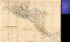
One sheet from Reiner & Josua Ottens rare 6 sheet map of the region, showing the Theater of the War of Jenkins Ear.
The 1740s marked a period of significant exploration, colonization, and geopolitical shifts in the New World. Reiner & Josua Ottens, accomplished Dutch cartographers, encapsulated this era's essence in their map sheet of the Gulf of Mexico and its adjoining regions.
This sheet provides an intricate representation of the southern part of present-day Mexico and Central America:
-
Tlascala: An ally of the Spaniards during the conquest of the Aztec Empire, Tlascala by the 1740s was fully under Spanish control, its native rulers having subordinated roles.
-
Guaxaca (Oaxaca): Known for its indigenous cultures, this region became crucial for its agricultural potential, especially in the production of indigo and cochineal dye.
-
Tabasco: This Gulf coast region experienced increased trade and Spanish settlement by the 1740s, though indigenous cultures still had a strong presence.
-
Chiapas: The 1740s saw intensified Spanish missionary activities here, aiming to convert the indigenous population.
-
Soconusco: As a key cacao-producing region, it remained an area of economic importance.
-
Guatemala: By this period, Guatemala City had been established as the region's capital, emphasizing the growing Spanish colonial infrastructure.
-
Vera Paz: Known for its challenging terrain, Spanish missionaries worked tirelessly to pacify and convert the local populations.
-
Honduras: The mining activities in this region, especially silver extraction, attracted Spanish settlers and increased trade activities.
-
Nicaragua: The Spanish colonization was well-established, with Granada and León as primary cities, both serving as regional capitals at different times.
-
Yucatan: The Spanish had established Campeche and Mérida as primary cities, though the legacy of the Mayans persisted.
The map also prominently features two insets:
-
"Nouveau Plan du Port et de la Ville D'Acapulco": Acapulco by the 1740s had become the linchpin in the trans-Pacific trade, with the Manila-Acapulco Galleon trade at its height.
-
"Plan de la Vera-Cruz Port du Mexique": As the primary port for New Spain, Vera-Cruz facilitated most of the trade between the colony and Spain.
The 1740s were marked by consolidation of Spanish control in these regions. Indigenous resistance persisted, but large-scale rebellions were less common than in previous decades. The Catholic Church, through missions and parishes, played a pivotal role in the colonization process, both spiritually and in terms of governance.
Trade flourished, both within the colonies and with the outside world. The galleon trade connected Asia and the Americas, bringing luxury goods like silk and porcelain to New Spain, while the ports on the Gulf of Mexico connected the colony with the Spanish mainland.
While the map serves as a representation of the region's geography, the territories marked and the prominence given to certain ports and routes also indicate the economic and strategic priorities of the European powers during this period.
The sheets were issued separately and as part of a large six-part map illustrating the War of Jenkin's Ear in 1740-41.
The complete set is rare on the market.
The Ottens brothers, Reiner and Joshua, operated a successful printing partnership in the mid-eighteenth century (fl. 1726-1765). They began the venture in 1726, publishing maps and other prints as “R & I Ottens.” They specialized in the reprinting of others’ work, especially Guillaume De L’Isle. In 1750, Reiner died; his soon, also Reiner, took his place, but the firm began listing their works as “Joshua & Reiner Ottens.” The firm lasted until Joshua’s death in 1765. Joshua’s widow, Johanna de Lindt, sold their remaining stock of plates in 1784.
![A Map of British Honduras... [bound in:] Tratado de Limites Entre Los Estados-Unidos Mexicanos y Honduras Britanica Seguido de los principales documentos que a el se refieren. Edicion Oficial.](https://storage.googleapis.com/raremaps/img/small/70984.jpg)