


|
||

|

|
|

|
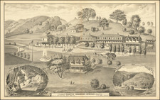
San Francisco Bay Model Sausalito California, published by the U.S. Army Engineer District in San Francisco in May 1959, presents an enlightening visualization of the San Francisco Bay through a scientifically accurate hydraulic model. Situated in the heart of Sausalito, the model was an instrumental tool for engineers to address complex hydraulic issues and to predict the outcomes of potential infrastructural changes within the Bay Area.
The late 1950s marked an era of rapid urban development and infrastructural evolution in the San Francisco Bay region. The hydraulic model, established as a part of an expansive engineering study authorized by Congress in 1950, emerged as a testament to the foresight of engineering practices of the time. By scaling the region horizontally at 1 ft to 1000 ft and vertically at 1 ft to 100 ft, the model extended from Alviso to Napa and spanned from the Pacific Ocean to near Antioch. Though not an exact replica in appearance, its functionality mirrored the Bay's intricate tidal patterns, water flows, mixing of saline and freshwater, and sediment deposition trends. Such detailed representation offered engineers a unique insight into the Bay's inherent physical forces and their potential transformation in the face of human interventions.
The incorporation of the model into a specially adapted warehouse in 1955, with its construction commencing in March 1956, signaled a notable investment in understanding and preserving the delicate balance of the Bay's ecosystem. It was designed with a specific focus on the study of salt-water barriers and the shoaling of waterways. With its scheduled completion in 1962, this model stood not only as an embodiment of advanced hydraulic study but also as an accessible resource, with public visiting hours ensuring an educational avenue for the broader community.
This folding pamphlet, complete with its map and an inset plan of the model, further reinforces the sheer magnitude of this scientific undertaking. The photo overview, paired with a detailed essay, provides readers a comprehensive understanding of the model's purpose, design, and significance. Through this document, the intertwining narratives of scientific progress, ecological consciousness, and urban development within the San Francisco Bay Area during the mid-20th century come vividly to life.
![[ Washington Township / Murray Township ] Res. & Stock of J.T. Walker, Washington on Corners & Residence and Farm of Christian Knittel, Murray Tp, Alameda County, California](https://storage.googleapis.com/raremaps/img/small/102042.jpg)
![[Maximum Berkeley] A Map of Berkeley, Oakland & Alameda](https://storage.googleapis.com/raremaps/img/small/50325.jpg)
![Alameda County, California. Showing The Automobile Roads and Principal Points of Interest . . . [Livermore Valley Views]](https://storage.googleapis.com/raremaps/img/small/76961.jpg)
![[ San Francisco / Bay Area ] Welcome Map of San Francisco and the Bay Area](https://storage.googleapis.com/raremaps/img/small/96705.jpg)