|
||

|

|
|

|
A Mid-19th-Century Manhattan Rarity.
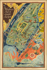
Phelps' New York City Map, With Portions of Brooklyn, Jersey City, Williamsburgh, Greenpoint, Astoria, and Hoboken, a rare wall map published by Humphrey Phelps in 1857, presents a wide-ranging portrayal of New York's intricate urban tapestry. Embellished with many wood-engraved vignettes, the map delineates the city's expanding streets and boundaries and spotlights key public buildings, marking them as emblems of civic achievement and architectural significance. Interestingly, Phelp's map retains numerous old paths and waterways north of 40th Street. Although many were obscured by Manhattan's grid development, several still influence the spatial layout of the borough.
Central Park
In 1857, New York City was on the precipice of one of its most ambitious urban development projects: the creation of Central Park. As the city's population surged, there was a growing recognition of the need for an expansive public space to serve as a recreational and aesthetic haven for its residents. The city's commissioners organized a design competition, eventually selecting the "Greensward Plan" proposed by Frederick Law Olmsted and Calvert Vaux. Central Park, with its winding pathways, rolling meadows, and tranquil lakes, was envisioned as a pastoral escape from the urban hustle, embodying the Romantic ideal of nature within the metropolis. This year also witnessed other changes in the city's fabric. The street grid continued its march uptown, and infrastructural developments, including roads and public transport, were evolving to accommodate the burgeoning populace. The pressures of rapid urbanization, economic fluctuation, and increased immigration also culminated in the Panic of 1857, an economic crisis that further underscored the city's intertwined destinies of growth, ambition, and challenge.
Mount Morris Park
Mount Morris Park, currently known as Marcus Garvey Park, is a historically important green space in Harlem. Covering over 20 acres, the park is home to the Mount Morris Fire Watchtower, the last remaining cast-iron watchtower in the city. Throughout its existence, the park has served as a cultural hub for Harlem residents, hosting numerous events, festivals, and community gatherings. Its presence has made it an enduring symbol of community unity and a testament to the vibrant cultural heritage of Harlem.
Decorative Elements
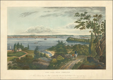
The vignettes selected by Phelps, ranging from "The City Prison, called The Tombs" to "The Merchants' Exchange, Wall Street," present a cross-section of New York's multifaceted urban life, emphasizing its commitment to varied institutions—educational, penal, religious, and mercantile. The inclusion of landmarks such as "The Union, or Cooper Institute" (i.e., Cooper Union) and "The New York Free Academy" underscores the city's burgeoning emphasis on education and intellectual growth. Similarly, the dedication to charitable institutions like "The New York Orphan Asylum" reveals the urban sprawl's more compassionate side, while the vignette of "The Deaf and Dumb Institution" highlights the city's inclusive ethos. These structures, represented with precision and detail, serve as a testament to New York's architectural renaissance during this era, capturing both its stylistic and functional evolution.
An interesting feature of this map is its historical juxtaposition, providing a "Birdseye View of New York From Union Square" while also transporting viewers back in time with a portrayal of "New Amsterdam or New York in 1657, showing the Old Fort on what is now the Battery." This deliberate contrast encapsulates New York's rich heritage, blending its Dutch colonial origins with its contemporary stature. Additionally, the comprehensive "Map of Hudson River" (from NYC to Troy) and the depiction of "Thirty Miles Around New York City, with the Town and County Boundaries" showcase the geographical reach and centrality of the city.
Crucially, Phelps' map goes beyond mere geographical representation, incorporating pragmatic annotations explaining ward numbers, fire district delineations, and railroads. These details provide valuable insights into the administrative and infrastructural fabric of the time, alluding to the city's structural organization and the modes of connectivity driving its inexorable growth.
Rarity
Not to be confused with Phelps's 1857 smaller guide map, "New York City Map". While fairly well represented in institutional collections, this impressive map is rarely seen on the antiquarian market; the last record on OldMaps.com is 25 years old.
![[Harlem]. Map of the Harlaem Commons surveyed agreeably to the boundaries established by the Commissioners appointed to settle the boundary lines between the common lands of the City of New York and the Town of Harlaem...](https://storage.googleapis.com/raremaps/img/small/59385.jpg)