


|
||

|

|
|

|
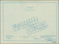
Plat Map of Downtown San Diego During the Boom Years of the 1880s
California Central Railroad Right of Way - Near Present Santa Fe Depot
A detailed manuscript plat map of the Embarcadero area of downtown San Diego just north of Broadway. The area shown is bounded in the north by B Street, to the south by D Street (present day Broadway), in the west by Atlantic Street (present day N. Harbor Drive), and on the east by State Street. Many of the blocks are identified by their owners: Gardiner and Bleeker; Davidson; Barber; Tremain; Barber; Fitzgerald; and Murray. The map was made for a court case, California Central Railroad vs. Geo. F. Hooper, and is dated as filed on December 13, 1887.
Chartered in January 1887, the California Central Railroad consisted of eight short lines, the result of the Santa Fe's consolidation efforts that also included the California Southern. The "proposed right of way" of the California Central Railroad is shown penciled across the Gardiner and Bleeker block, while the route of the California Southern Railroad is properly inked-in along California Street (modern day Pacific Highway). The Gardiner & Bleeker lot is today a significant plot of land filled with highrise condos and buildings, just west of the current Santa Fe Depot.
Gardiner and Bleeker's store makes an appearance in George Horatio Derby's classic book Phoenixiana (1855). Derby, who served in the army's Corps of Topographical Engineers, was a noted humorist and described what he saw in early San Diego with tongue firmly planted in cheek:
The three villages then, which go to make up the great city of San Diego, are the "Playa," "Old Town," and "New Town," or "Davis's Folly." At the "Playa" there are but few buildings at present, and those not remarkable for size or architectural beauty of design... Then there is the "Ocean House" (that's Donahoe's), and a store marked Gardiner & Bleeker, than the inside of which nothing could be bleaker, for "there's nothing in it".... From the present appearances, one would be little disposed to imagine that the "Playa" in five or six years might become a city the size of Louisville, with brick buildings, paved streets, gas lights, theatres, gambling houses, and so forth. It is not at all improbable, however, should the great Pacific Railroad terminate at San Diego, an event within the range of probability, the "Playa" must be the depot, and as such will become a point of great importance. The landholders about here are well aware of this fact, and consequently affix already incredible prices to very unprepossessing pieces of land. Lots of one hundred and fifty feet front, not situated in particularly eligible places either, have been sold within the last few weeks for five hundred dollars apiece.... Phoenixina, or Sketches and Burlesques, page 208.
By 1887, San Diego was in a phase of rapid development and transformation, as railroad connections (real and imagined) precipitated a booming speculative real estate market. The present map seems to establish the embarcadero area as a likely place for a railroad depot, adjacent to the wharves (or future wharves) near the present day Broadway pier. The map stems from legal issues over railroad rights of way through downtown San Diego.
M. G. Wheeler was San Diego County Surveyor from 1872 to 1875. According to Curtis Brown, Wheeler also worked as a railroad engineer and often partnered with James Pascoe, a prolific early San Diego surveyor known for his map of the Pueblo Lands of San Diego.
Streets shown:
- Atlantic (present N. Harbor Dr.)
- California (present Pacific Highway)
- Arctic (present Kettner)
- India
- Columbia
- State
- B Street
- C Street
- D Street (present Broadway)
In sum, the map provides insight into land-use issues and infrastructural development that shaped downtown San Diego in the late 19th century. Its role as an exhibit in a legal case, underscores the complex negotiations and disputes that often accompany periods of rapid urban growth.
![[ Naval Base San Diego / California Southern Railroad ] Referee's Map of Pueblo Lot 1166 in City of San Diego . . . .](https://storage.googleapis.com/raremaps/img/small/96386.jpg)
![[Oceanside and Camp Pendleton]](https://storage.googleapis.com/raremaps/img/small/71834.jpg)
![[ La Jolla ] La Jolla Street Map](https://storage.googleapis.com/raremaps/img/small/100138.jpg)