|
||

|

|
|

|
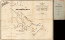
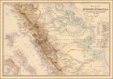
A New Chart of the Banda Sea, published by Laurie and Whittle in London on 4th June 1799, delineates the maritime region of the Banda Sea, including prominent islands such as Amboyna, Banda, and Bouro, and further stretches to the northeastern end of Timor. Enriched with insets that illustrate the Bay of Amboyna and the isles of Banda, Goonong-Appee, and Banda-Neira, this chart serves as an essential tool for understanding the navigation and geography of the area during the cusp of the 19th century.
In the closing years of the 18th century, European maritime exploration and trade were reaching their zenith. The Banda Sea, situated within the Indonesian archipelago, was a focal point of these endeavors. Not only were these waters rich with spices and other valuable commodities, but they were also vital routes for ships navigating between the far reaches of the Asian continent and the colonial powers of Europe.
Laurie and Whittle's publication captured the maritime details with precision, as evident in its notations. Annotations such as "the Three Eastern Noossa Pinhos of Valentyn" and "the Dizzy Reef" offer mariners significant information about local landmarks and potential hazards. Meanwhile, the references to "Luca-parros of Dampier" and "the Luceparas of the Taunton Castle August 28 1797" evoke maritime tales and voyages, emphasizing the chart's historical context and the continued European exploration of the region.
Moreover, the note "They are Low Woody Islands and cannot be seen from the Deck above 4 Leagues" underscores the practical nature of the chart. Such information would have been indispensable for sailors navigating unfamiliar and treacherous waters, where the margin for error could be perilously slim.
The presence of insets further enhances the chart's utility and informational richness. The "Plan of the Isles of Banda, Goonong-Appee and Banda-Neira," for instance, offers detailed topographical insights into these islands. Together with the primary map, these insets create a comprehensive picture of the Banda Sea and its surrounding islands during a period of heightened European interest and interaction with Southeast Asia.
Robert Laurie (ca. 1755-1836) and James Whittle (1757-1818) formed their Fleet Street, London-based firm upon the 1794 death of their employer Robert Sayer, himself one of the dominant print and mapmakers of the last half of the 18th century.
Laurie & Whittle started managing Sayer's business as early as 1787. They took over all managerial duties when Sayer's health flagged in 1792, and they changed the imprint in 1794 upon his death. Sayer left the two a 21-year lease on the shop (at £100 a year) and on Sayer's Bolt Court premises, as well as an option to acquire stock and equipment at a preferential price of £5,000 payable over three years.
Robert Laurie retired from the firm in 1812, and his role was assumed by his son, Richard Holmes Laurie (1777-1858). The younger Laurie worked with James Whittle until the latter died in 1818. After R. H. Laurie died in 1858, Alexander George Findlay, FRGS (1812-1875) purchased the firm from his daughters. The firm continues today under another name, specializing in yachting charts.
Laurie & Whittle were prolific print and map publishers, and throughout their careers, they produced numerous very important and rare works. They carried on Robert Sayer's atlas business and were responsible for editions of The Complete East-India Pilot and The American Atlas.