|
||

|

|
|

|
Virtually Unknown Gold Rush Era Map of the Black Hills
This large and very rare map of the Black Hills, published at the height of the gold rush in 1877, stands as a singular representation of that region, distinct in its design and information from the other maps of the period.
The map is known in but one institutional copy (Minnesota Historical Society) and, as far as we can see, has never appeared on the antiquarian market. It was produced by the St. Paul Lith. Co., a firm specialized in small-run jobs, especially producing the kinds of maps that went directly into use on the northern Plains. These practical publications (as opposed to those intended for office and library use) are necessarily some of this period's rarest and most illuminating documents.
In a broader sense, the Black Hills Gold Rush embodied several of the fundamental themes of American westward movement: the clash of indigenous cultures with expansionist ambitions, the transformative power of mineral wealth, and the profound environmental and social shifts borne of rapid colonization.
The Black Hills Gold Rush
The Black Hills Gold Rush began in the 1870s when gold was discovered in the Black Hills region of South Dakota. Sparked by George Armstrong Custer's 1874 Black Hills Expedition and confirmed by the findings of geologist Walter P. Jenney, news of the discovery drew thousands of prospectors to the area, leading to the establishment of boomtowns such as Deadwood. The influx of miners and settlers into the territory infringed upon the land guaranteed to the Lakota Sioux by the Treaty of Fort Laramie in 1868. The U.S. government's efforts to buy or seize the Black Hills, combined with the gold rush, escalated tensions and culminated in the Great Sioux War of 1876-77. The war ended with the gradual surrender of the Cheyenne and Sioux bands in early 1877. This gave the Federal Government the pretext it needed to pass “The Agreement of 1877” (aka “The Act of February 28, 1877”). This act forced the Sioux to cede a 50-mile-wide strip of reservation land along the western border of Dakota, including the Black Hills, thus legalizing the white settlement of the region, which was already a fait accompli. The mining activity in the region led to the extraction of an estimated $300 million worth of gold during the late 19th and early 20th centuries.
As with other 19th-century gold rushes, the Black Hills Gold Rush fomented a frenzy of publication to supply much-needed information to prospective miners and hangers-on. Publishers nationwide, and particularly in the upper Midwest, produced a bevy of guidebooks, promotional ephemera, and maps to satisfy the explosive demand. The present map is one of the largest and rarest maps of the Black Hills to come out of the 1876-77 height of the gold rush.
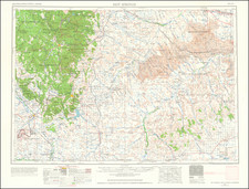
The Map
Butler’s Map depicts a roughly 30-by-24-mile region of territorial South Dakota and Wyoming, bounded by the North and South Forks of the Cheyenne River. Waterways are delineated; elevations are indicated somewhat sketchily by hachuring and some major peaks named; and scattered notes describe the character of the landscape—“timber”, “prairie”, “oak in clumps”, “springs”, &c. Deadwood, Leadville, Spearfish, and other recently-settled Gold Rush towns are indicated, connected with each other and larger towns to the east by very few roads and trails. The long, counterclockwise loop of the 1874 Custer Expedition is also shown.
The map was presumably issued some time after the end of the Great Sioux War and the passage of The Agreement of 1877, as it makes absolutely no mention whatsoever of the Great Reservation or the Cheyenne or Sioux presence in the region.
A close look at some of the toponyms provides additional information about the possible dating of the map. "Golden City," north of Custer, was renamed Sheridan in 1877. Both "Crook City" and "Camp Crook" were named after General George Crook, who led an expedition through the Black Hills in 1876.
Who was Butler?
The map’s origins are shrouded in mystery. It claims to be "compiled from U.S. Surveys and Personal Observations," but it doesn’t particularly resemble other major maps of the period, such as Custer’s Map of a Reconnaissance of the Black Hills (1874?), the Topographical Engineers map of the Dakota Territory (1875), or Thayer’s Map of the Black Hills & Big Horn Country (1877). Nor can we determine whose "personal observations" are reflected in the map. We find no advertisements for it in the contemporary press; thus, the identity of the “Butler” named in the title remains unknown. As to Butler’s identity, we can only speculate.
There are a few tantalizing "Butler" candidates who were in the Black Hills in 1876-77: In 1877, George Harris Butler (1840-May 11, 1886) was appointed Special Postal Agent for the Black Hills territory in Deadwood; however, while on his way to the post, he became drunk and accosted a Methodist pastor and was fired before assuming the position. Circumstantial evidence suggests he continued out West. And while nothing indicates he spent significant time in the Black Hills, his biography is too fascinating and louche not to mention him here. Another very long-shot candidate is James Butler (a.k.a. "Wild Bill") Hickok (1837–1876). Hickok was a legendary American frontiersman, scout, and gunslinger known for his poker skills and involvement in gunfights during the Old West era. Wild Bill was shot dead in Deadwood in 1876, just close enough to the map's publication to allow us to mention him! There were, of course, a host of lesser-known Butlers in the Black Hills around this time; for instance, Squire Butler started a jewelry store in Deadwood in 1877. But for now, the question remains open.
Rarity
The map is extremely rare. We find but a single institutional holding (Minnesota Historical Society) and no record of its having been offered on the antiquarian market.
In all, an extraordinarily rare and informative cartographic artifact, with great immediacy to the events of the Black Hills Gold Rush and the tragic conclusion of the Great Sioux War.
![[ State of Lincoln! ] British Columbia and the North West Territory](https://storage.googleapis.com/raremaps/img/small/60518.jpg)
![Dacota-Krieger. Guerrier Dacota [Dakota Warrior, Wahk-Tä-Ge-Li, or Big Soldier]](https://storage.googleapis.com/raremaps/img/small/81195.jpg)