


|
||

|

|
|

|
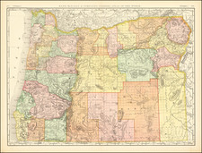
Road and Recreation Map of State of Oregon, prepared by the Forest Service of the U.S. Department of Agriculture and published in 1928, offers an in-depth perspective on Oregon's transportation and recreational landscape as of March 1927. Charting both the state's established roads and proposed developments, this map serves as a vivid testament to Oregon's dynamic infrastructure and the foresight of the Forest Service in anticipating the needs and desires of a burgeoning automobile-oriented society.
In the 1920s, Oregon stood on the brink of major infrastructural changes. As the United States began its headlong dive into the era of the automobile, the importance of well-maintained and expansive road networks became paramount. This map captures that transitional period when the state rapidly adapted to the demands of automobile transportation, laying out trunk highways, and designating national highway route numbers, such as the US 30. The inclusion of proposed road projects earmarked for the summer of 1927 further underscores the constant evolution and expansion of the state's transport matrix during this decade.
Beyond merely serving as a testament to transportational advancements, the map highlights the recreational hubs and natural sanctuaries of Oregon. The identification of national forest recreation centers and national parks, like the emblematic Diamond Lake as indicated on the cover, showcases the Forest Service's commitment to preserving and promoting the state's natural wonders. Such features resonate with the broader ethos of the 1920s, which saw a heightened appreciation for outdoor recreation and conservation.
The verso of the map is adorned with essays and tables, delving deeper into the rich tapestry of Oregon's natural landscapes and the manifold opportunities they presented for recreation. Such comprehensive coverage underscores the dual role this map plays, serving both as a guide to the state's evolving road network and as an invitation to explore Oregon's storied wilderness.
Additionally, the periodic revisions made to the map—evident from the dates of revision in 1924, 1926, and the final printing in 1928—speak to the meticulous nature of the Forest Service in ensuring that the map remained current and accurate. Such consistent updates further solidify its position as a vital document, capturing the pulse of a state in flux and the tireless efforts of its administrators to keep pace with these changes.

![(California - 19th-Century Photographs) [Album of 33 photographs of California, Oregon, and Washington, including Yosemite Valley, Stanford University, Sutro Heights in San Francisco; Mt. Hood; Mt. St. Helens; Portland, Oregon]](https://storage.googleapis.com/raremaps/img/small/94083.jpg)
![[ Pacific Coast Pictorial Road Maps ] Scenic Touring Scout](https://storage.googleapis.com/raremaps/img/small/101745.jpg)