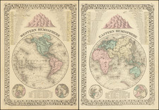
|
||

|

|
|

|
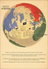
U.S. Air Force Physical-Political Global Chart of the World, published by the USAF Aeronautical Chart and Information Center in 1954, offers a unique representation of global relationships, emphasizing the significance of the Northern Hemisphere. Reflecting the geopolitical and spatial dynamics of its time, the map's Stereographic Projection was devised to present a more realistic visualization of the areas deemed most crucial, predominantly located in the Northern Hemisphere, which, according to the map, was home to 90% of the world's population.
In the mid-twentieth century, as nations navigated the intricacies of a world recovering from war and evolving geopolitics, the representation and understanding of global space became paramount. During this period, the Cold War set the stage for an intensified race in technology and information. This chart, with its detailed emphasis on the Northern Hemisphere, aligns with this context, underscoring the strategic importance of regions that were central to these global power dynamics.
The chart’s utilization of the Polar Stereographic Projection for the Northern Hemisphere is particularly notable. This method was chosen for its capacity to preserve geographical shapes and offer accurate directional and distance measurements over extensive areas, making it optimal for representing large sections of the globe like hemispheres. On the other hand, the Southern Hemisphere's presentation was designed for continuity and shape accuracy, though it made concessions in the property of conformality and distance accuracy towards its outer regions.
Furthermore, the inclusion of a detailed legend that differentiates political features, transportation avenues, and physical landscapes provides readers with a comprehensive understanding of both human-made and natural global features. The specific note regarding the non-recognition by the U.S. government of certain territorial incorporations, such as Estonia, Latvia, and Lithuania into the Soviet Union, adds a layer of political nuance, subtly reflecting the geopolitical tensions of the era.
Elevation and topography have been depicted through color gradations, offering a multi-dimensional view of the world's landscapes. Such nuanced representations, combined with its historical context and purposeful projection choices, make this chart a compelling testament to the cartographic, political, and strategic priorities of its period.
![[Early Fascimile of the Disputed Christopher Columbus Portolan Chart]](https://storage.googleapis.com/raremaps/img/small/66588.jpg)
![[Signed Political Satire Artwork] Vietnam ... Vietnam ... Vietnam ...](https://storage.googleapis.com/raremaps/img/small/68726.jpg)