|
||

|

|
|

|
Stock# 96897
Description
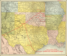
Texas-Mexico Border -- Tracking The Rio Grande River
U.S. Air Force edition of the World Aeronautical Chart for part of Chihuahua and West Texas.
The chart declares itself the Fourteenth Edition, published on February 23, 1952.
Covers the Rio Grande River Valley from El Paso to the area east of Big Bend.
![Carta geografica della Florida nell'America settentrionale [Geographical map of Florida in North America]](https://storage.googleapis.com/raremaps/img/small/84142.jpg)
![(Texas - Spanish Colonial Era) [Manuscript document of 1692 concerning Bahia del Espiritu Santo on the Texas Gulf Coast, signed by the Viceroy's secretary, Juan Francisco de Vargas Manuel de Lodeña]](https://storage.googleapis.com/raremaps/img/small/95766.jpg)

![(Texas Photograph) [Cabinet Card Birdseye View of El Paso, Texas and Ciudad Juarez]](https://storage.googleapis.com/raremaps/img/small/92983.jpg)