|
||

|

|
|

|
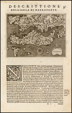
This bird's-eye view from Braun & Hogenberg's renowned Civitates Orbis Terrarum depicts Chios, a historic city on its eponymous Aegean island, renowned for its seaport and rich cultural heritage. The view is a testament to the city's thriving commerce and strategic importance in the late 16th century, capturing its layout and vibrant maritime activity.
The depiction of Chios in this engraving is particularly notable for its detailed portrayal of the city's dual structure: the fortified Byzantine Castro and the urban settlement. This division highlights the historical significance of Chios as a fortified island, reflecting its tumultuous past marked by multiple sovereignties. The inclusion of the Castro, with its imposing watchtowers, moat, and drawbridge, speaks to the city's defensive strategies against frequent invasions and its strategic position in the Aegean Sea. Conversely, the representation of the urban area provides insight into the daily life and architectural style of the period.
Chios's history is deeply intertwined with its economic pursuits, most notably its production of Chian wine and mastic, a resin unique to the island. The commentary by Braun on the verso of the engraving emphasizes the island's historical reputation for these products, as attested by ancient historians like Thucydides, Strabo, and Aelian. This economic focus not only underlines the island's agricultural richness but also its significance in ancient trade networks. The presence of windmills along the coastline in the engraving further accentuates the island's agricultural fertility and its role in the regional economy.
The geopolitical context of Chios during the late 16th century adds another layer of historical depth to the engraving. The island's shift from Venetian to Genoese control, and ultimately to the Ottoman Empire in 1566, indicates the broader political and cultural shifts in the Mediterranean during this era. The conversion of the 10th-century church of Aghios Nikolaos into a mosque post-1566, as depicted in the engraving, symbolizes these shifts and reflects the complex interplay of different cultures and religions on the island.
Georg Braun (1541-1622) was born and died in Cologne. His primary vocation was as Catholic cleric; he spent thirty-seven years as canon and dean at the church St. Maria ad Gradus, in Cologne. Braun was the chief editor of the Civitates orbis terrarum, the greatest book of town views ever published. His job entailed hiring artists, acquiring source material for the maps and views, and writing the text. In this role, he was assisted by Abraham Ortelius. Braun lived into his 80s, and he was the only member of the original team to witness the publication of the sixth volume in 1617.
Frans Hogenberg (ca. 1540-ca. 1590) was a Flemish and German engraver and mapmaker who also painted. He was born in Mechelen, south of Antwerp, the son of wood engraver and etcher Nicolas Hogenberg. Together with his father, brother (Remigius), uncle, and cousins, Frans was one member of a prominent artistic family in the Netherlands.
During the 1550s, Frans worked in Antwerp with the famous mapmaker Abraham Ortelius. There, he engraved the maps for Ortelius’ groundbreaking first atlas, published in Antwerp in 1570, along with Johannes van Deotecum and Ambrosius and Ferdinand Arsenius. It is suspected he engraved the title page as well. Later, Ortelius supported Hogenberg with information for a different project, the Civitates orbis terrarium (edited by Georg Braun, engraved by Hogenberg, published in six volumes, Cologne, 1572-1617). Hogenberg engraved the majority of the work’s 546 prospects and views.
It is possible that Frans spent some time in England while fleeing from religious persecution, but he was living and working in Cologne by 1580. That is the city where he died around 1590. In addition to his maps, he is known for his historical allegories and portraits. His brother, Remigius, also went on to some fame as an engraver, and he died around the same time as his brother.