


|
||

|

|
|

|
An interesting historical collection of maps relating to Pennsylvania borders:
1. A Plan of Boundry Lines Between the Province of Maryland...: Manuscript Annotations bear the signatures of the men listed above the text. Implies that this map (likely not this copy?) was presented to King George III in 1786. Another annotation on the right side reads "Presented to the Commonwealth of Pennsylvania 30th. January 1837 by Benjamin Chew Chiseden(?)- Philadelphia County. " Toning along folds. Slight offsetting on left. Minor tear as pictured. Wonderful cartouche done by J Smither depicts natives hunting with bows and cartographic instruments. Map is largely blank but with intricate details only on the border between Maryland and Pennsylvania.
2. Map of Maryland, Pennsylvania, and Delaware (1849-50) : Orginal hand coloring. Several manuscript annotations. One reads: "I certify that this Map exhibits a true and correct delineation of the portion of the conterminous boundaries, here represented, of the States of Pennsylvania, Maryland, and Delaware, derived from actual surveys truly and faithfully made under my direction and supervision between the 16th of November 1849 and the 6th of February 1850, at the request of the Commissioners of the said states appointed for the said states appointed for re-marking the same. Washington, February 27 1850. J. B. Graham." The other annotations are the approval signatures of the commissioners from Maryland, Pennsylvania, and Delaware. Expected toning along folds. Minor offsetting on right.
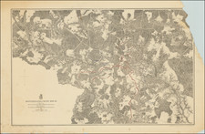
3. Meridian Boundry of West Virginia and Pennsylvania: Manuscript annotations include signature of James Worrall. Expected toning along folds. Three skinny maps that all depict the boundary between West Virginia and Pennsylvania. Bold line may show the determined boundary line with the dashed lines representing previous ones or changed boundaries.
4&5. State Line Between Pennsylvania and West Virginia: Manuscript annotations: signatures of the surveyor, the state commissioners, and secretary of internal state affairs for Pennsylvania. Toning along folds. image 5 is the same map/duplicate (?) image
6. A Map of the Western Boundry of Pennsylvania: Colored red line for boundary. Toning along folds. Title indicates that this is a 1786 map created by Benjamin Bartin, likely a reprint for whatever this collection is.
7. Map of the Boundry Line Between the States of Pennsylvania and Ohio: Toning where folded. Slight foxing on the right as pictured.
8. Map of the Boundry Line Between New York and Pennsylvania Along Wayne County...: Manuscript annotations include signatures of the surveyors for PA and NY. Light foxing along the corners. Toning along folds. Slight offsetting as pictured. Drawn by Harry C. Allen. Colored red for boundary and granite monuments built along it, blue for waterways. Shows monument construction done in 1882 and 1884
9&10. Map of the Boundry Line Between New York and Pennsylvania Along Bradford County...: Manuscript annotations include signatures of the surveyors for PA and NY. Toning along folds. Slight offsetting as pictured. Drawn by Harry C. Allen. Two identical maps, one is in slightly better condition. Both maps colored with red boundaries and granite monuments built along it, blue for waterways. Shows monument construction done in 1881-84
11. Map of the Boundry Line Between New York and Pennsylvania Along Tioga County...: Manuscript annotations include signatures of the surveyors for PA and NY. Toning along folds. Slight offsetting as pictured. Drawn by Harry C. Allen. Map drawn with red boundaries and granite monuments built along it, blue for waterways. Shows monument construction done in 1882-84
12. Map of the Boundry Line Between New York and Pennsylvania Along Potter County...: Manuscript annotations include signatures of the surveyors for PA and NY. Toning along folds. Slight offsetting as pictured. Drawn by Harry C. Allen. Map drawn with red boundaries and granite monuments built along it, blue waterways. Shows monument construction done in 1884.
13. Map of the Boundry Line Between New York and Pennsylvania Along McKean County...: Manuscript annotations include signatures of the surveyors for PA and NY. Toning along folds. Slight offsetting as pictured. Drawn by Harry C. Allen. Map drawn with red to indicate boundary and granite monuments built along it, blue waterways. Shows monument construction done in 1884.
14. Map of the Boundry Line Between New York and Pennsylvania Along Warren County...: Manuscript annotations include signatures of the surveyors for PA and NY. Toning along folds. Slight offsetting as pictured. Drawn by Harry C. Allen. Map drawn with red to indicate boundary and granite monuments built along it, blue waterways. Shows monument construction done in 1884.
15. Map of the Boundry Line Between New York and Pennsylvania Along Erie County...: Manuscript annotations include signatures of the surveyors for PA and NY. Toning along folds. Slight offsetting as pictured. Drawn by Harry C. Allen. Map drawn with red to indicate boundary and granite monuments built along it, blue waterways. Shows monument construction done in 1884.
16. Map of the Boundry Line Between New York and Pennsylvania Upon the Meridian of the West End of Lake Ontario...: Manuscript annotations include signatures of the surveyors for PA and NY. Toning along folds. Slight offsetting as pictured. Drawn by Harry C. Allen. Map drawn with red to indicate boundary and granite monuments built along it, blue waterways. Shows monument construction done in 1884-5.
17. 4 sketches of boundaries: Toning along folds. Otherwise quite good. Sketch 7 shows a part of the Deleware River near the "Initial Point" which shows a rough idea of the Merdian mark and boundaries of the area. Several areas are noted with question marks on them, perhaps indicating their relation to the other sketches. The next two sketches show irregularities between various milestones. These two sketches show the red boundary line between various locations and how they were determined. Dates of 1787, 1786, and 1879 may show different years that boundaries were drawn. Final sketch shows the adjustment made to the southern end of the Merdian boundary between New York and Pennsylvania. A dashed line that bisects around the 4.5 MP indicates the original boundary and new adjustment.
18: 3 sketches of boundaries: Toning along folds. Otherwise quite good. Sketch 13 shows irregularities along the Seventh Latitude Stone. These two sketches show the red boundary line between various locations and how they were determined. Dates of 1787, 1786, and 1879 may show different years that boundaries were drawn or updated. Final sketch shows the adjustment made to the "Section Section" boundary between New York and Pennsylvania. Several lines run through this section that illustrate the boundary lines as of 1744, 1786, and 1877. The final sketch shows a larger-scale view of these boundaries and the various state boundary lines throughout the years.
19: Sketch No. 8 Showing the Adjustment of the Boundry Between Milestones 135 and 159: Toning where folded. Shows the boundary lines as established in 1787 and later in 1879. These parallels were determined via observations at surveying stations. Map illustrates creeks, roads, train tracks, and counties in the region. Drawn by Harry C. Allen
20: Sketch No. 14 Showing the Adjustment of the Boundry West of Milestone 208: Expected toning on folds. Some offsetting as pictured. Once again done by Harry C. Allen. Shows the adjustments to the county boundaries due to the adjustment made previously. Shows the border along the present day 42 parallel.
![[ The Marks of Sundry of the Chief Men of Virginia ] Aliquot Heroum Virginiae Notae.](https://storage.googleapis.com/raremaps/img/small/98859.jpg)
![(Kentucky Borderlands) [An original manuscript account detailing a trip to and from Kentucky via the Ohio River, including the return trip via the Old Wilderness Trail, with two hand-drawn plat maps] An Account of Expences in Travelling to and from Kentucky in search of Land Claimed by Mr. H. McClery & Myself.](https://storage.googleapis.com/raremaps/img/small/81445.jpg)
