|
||

|

|
|

|
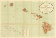
Maui the Valley Island of the Hawaiian Group, distributed by the Hawaii Visitors Bureau from the Kahului Airport in Maui, 1963, offers a visually evocative pictorial map of Maui, enriched with inset plans of significant localities such as Lahaina, Wailuku, Kahului, Kula-Makawao, and Hana.
The mid-20th century was a pivotal period for Hawaiian tourism. With increased accessibility via air travel, Hawaii was becoming a premier travel destination. It was against this backdrop that such informative guides emerged to cater to the inquisitive traveler. The map accentuates notable features such as main roads, secondary routes, trails, and a clear scale of miles, allowing visitors a comprehensive overview of the island's geography.
Rich in both natural beauty and cultural history, Maui is a tapestry of tales. Highlights include the Kanaha Bird Sanctuary, a winter retreat for migratory birds from the Northwest, and the ancient Haleki Heiau, a temple of worship and refuge, symbolizing the profound cultural and spiritual heritage of the island. Historical vestiges, such as the Bailey Mission Home from 1841 and the Baldwin Home, offer glimpses into the life of early missionaries and the influence of external cultures on the island. Educational landmarks like the Lahainaluna School, established in 1831 as the oldest school west of the Rocky Mountains, and Hale Pai, the site where Hawaii's first newspaper was printed in 1834, speak to the rich tapestry of Maui's intellectual and cultural evolution.
Furthermore, natural wonders like Haleakala National Park, described in Polynesian legends as the place where the demigod Maui ensnared the sun, captivate with their immense grandeur. The crater of Haleakala, characterized by its vividly tinted cinder cones, reflects both the island's volcanic origins and its current dormant tranquility. This map, thus, serves not just as a practical guide, but as an invitation to delve into the manifold wonders and stories that Maui holds.
![[California in Miniature] Bird's-Eye View Map Showing Its Prominent Topographical Features, Location of Principal Cities, Towns and Points of Note, Also Lines of the Southern Pacific Company. 1898.](https://storage.googleapis.com/raremaps/img/small/63460.jpg)