|
||

|

|
|

|
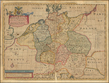
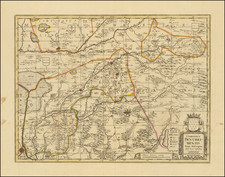
Holland, published by William Lizars in Edinburgh around 1830, provides a striking representation of the Dutch landscape and its significant landmarks. Highlighting the waterways, towns, and infrastructures, the map showcases Holland in the first third of the 19th century, a period during which the nation was experiencing both social and political transitions.
The 19th century was a dynamic era for Holland, marking its separation from Belgium in the 1830s and re-establishing itself as an independent kingdom. During this period, Holland witnessed urban advancements, trade expansion, and the solidification of its colonial empire. This map, therefore, not only delineates its geographical attributes but also metaphorically traces the nation's journey towards political and economic autonomy.
William Lizars' engraving exemplifies the intricacy and dedication associated with cartography of this age. His methodical representation of Holland's waterways is particularly noteworthy. The country, historically connected to water through its extensive canal system, sea trade, and battles against sea encroachments, finds a faithful reflection in this work. Lizars’ ability to capture the essence of this aquatic network suggests a deeper understanding of its significance to the Dutch identity.
Furthermore, the inclusion of various towns and landmarks on the map underscores the burgeoning urban and cultural evolution of Holland. As cities like Amsterdam and Rotterdam solidified their statuses as global ports and centers of arts respectively, this map stands as a testament to a nation in flux, capturing the delicate interplay between tradition and progress.
The Lizars were a Scottish family of engravers and printers who produced many views and maps. Daniel Lizars Sr. (1754-1812) was the son of a shoemaker, but he apprenticed with Andrew Bell, a printer and engraver. Lizars set up his own printworks near St. Giles Cathedral and took on his own apprentices, including George Bartholomew, whose son John would go on to found the important mapmaking firm later know as John Bartholomew & Son Ltd.
Daniel Sr. had three sons: Daniel Jr., John, and William Home. He also had a daughter, Jane Home. Daniel Jr. (1793-1875), the youngest of the boys, apprenticed in his father’s shop alongside George Bartholomew. When his father died in 1812, Daniel Jr. took over much of the business, expanding it and specializing in maps. The company went bankrupt in 1832, however, and Daniel emigrated to Canada.
John Lizars (1792-1860), the middle son, studied medicine and became Professor of Surgery at the Royal College of Surgeons of Edinburgh, as well as senior surgeon at the Royal Infirmary of Edinburgh.
William Home Lizars (1788-1859), the eldest, also apprenticed in his father’s shop. After learning engraving, William entered the Trustees’ Academy to learn under John Graham. He was a skilled painter and artist. When his father died, and after his Daniel Jr. left, he carried on printing and invented a method of etching that looks like wood engraving.
![[ Holy Roman Empire ] Germania del Gastaldo](https://storage.googleapis.com/raremaps/img/small/73754.jpg)