|
||

|

|
|

|
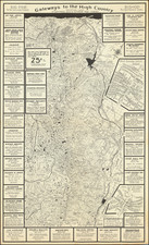
Live, Work and Play in the Beautiful Pajaro Valley, a pictorial map created by the artist Prendergast in 1945, offers an engaging visualization of the Pajaro Valley, emphasizing Watsonville, its surroundings, and key landmarks, including Monterey Bay, Pinto Lake, Kelly Lake, and prominent apple orchards. Emphasizing the region's natural beauty and infrastructural advantages, this map showcases Watsonville as a hub of activity and a place of significance within California.
In the mid-20th century, American towns and cities began creating promotional materials to attract residents, tourists, and businesses. Watsonville, positioned in California's rich agricultural Pajaro Valley, was no exception. This map serves as both a testament to the city's pride in its amenities and an invitation to potential visitors and residents. Features such as "SPLENDED HIGHWAYS," "EXCELLENT SCHOOLS," and "FINE CHURCHES" showcase Watsonville's growing urban infrastructure and its rich cultural fabric.
The map's artistic style, as rendered by Prendergast, captures the spirit of mid-century American cartographic design, which often combined aesthetics with utility. The pictorial nature of the map, illustrating both natural landscapes and human-made structures, encourages exploration and situates Watsonville as a nexus between agricultural prosperity and urban advancement. The verso, containing essays and photographic illustrations, further supplements the viewer's understanding of Watsonville, its infrastructural developments, and its significance in the broader context of California.
Emphasizing the ease of transportation to Watsonville through multiple modes — the Southern Pacific Railroad, Pacific Greyhound Bus Lines, personal cars, and airplanes — the map underscores the city's connectivity to broader networks. Beyond just a geographic representation, this map offers an intricate snapshot of Watsonville's character, community, and aspirations in the post-World War II era.
![[World] Air France --](https://storage.googleapis.com/raremaps/img/small/93647.jpg)