|
||

|

|
|

|
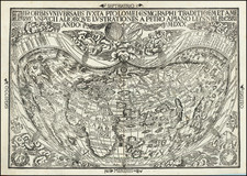
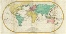
The Robert de Vaugondy Family's First Large World Map
Nice example of this rare double hemisphere map of the world by Gilles Robert de Vaugondy, the first such map by this illustrious mapmaking firm.
In 1743, this seminal piece of cartographic history emerged from the workshop of the Robert de Vaugondy family, destined to establish their reputation as leaders in the the French cartographic domain of 18th century. The map, entitled Mappemonde ou Description du Globe Terrestre, not only showcased the state of global knowledge but also stood as an anticipatory piece on the cusp of the age of Pacific exploration.
The map sets the stage for a significant era in world history, showing the known world just before major expeditions by the Russians, French, and English took center stage. In the coming years, explorations by the Russians (Vitus Bering, Grigory Shelekhov and Ivan Kruzenshtern), French (Louis Antoine de Bougainville and Jean François de Galaup, comte de La Pérouse) and English (James Cook, John Byron, Samuel Wallis, Philip Carteret, George Vancouver and William Bligh), would complete the geographical content of the known world.
Some of the more fascinating geographical myths, misconceptions and early information include:
-
Search for the Northwest Passage: The Latin phrase "ne ultra" – meaning no more – offers a rare and tantalizing glimpse into the yet undiscovered Northwest Passage to the Pacific. It speaks volumes about the vast uncharted territories and the possibilities they held.
-
Terre de la Compagnie: This area alludes to the journeys of João da Gama, the descendant of the illustrious Vasco de Gama. His mythical discoveries north of Japan in the late 16th century drew attention, and it was the Russians in the 1730s who renewed the quest to discover these lands.
-
Terre d'Yesso: The appearance of Terre d'Yesso indicates the uncharted territory of what we now recognize as Japan's northernmost part, Hokkaido.
-
Speculating on Australia's Shape: Australia, include a fascinating speculative outline shape, but is still lacking full depiction. The maker references important early findings like Tasman's discoveries and landmarks such as Terre de Leuwen, Terre de Nuits, and Terre du St. Esprit. The latter regions represent early European encounters with Australia, marking them as integral to understanding the continent's European exploration history.
-
New Zealand: Only a single, fragmented coast of New Zealand is depicted, based upon Abel Tasman's discoveries, underscoring the limited understanding of its geography at the time.
-
Antarctica In stark contrast to earlier map renditions filled with speculative southern continents, the Antarctic regions are aptly labeled 'Inconnues', embracing the vast unknown.
Pioneering Maritime Routes: Voyages of Discovery and Legacy
The map shows the routes of numerous important explorers:
- Vasco da Gama and the Cape of Good Hope (1487 (but 1497)): Though Bartolomeu Dias was the first to round the Cape of Good Hope in 1488, Vasco da Gama's expedition is more renowned because it successfully linked Europe and Asia by sea. Departing Portugal in 1497, Gama sought a direct maritime route to India, bypassing the Mediterranean and land-based Silk Road routes. His journey was fraught with challenges, including navigating uncharted waters, facing the hostile local populace, and enduring scurvy. However, in 1498, Gama reached Calicut in India, proving the feasibility of a sea route to the East. His expedition reshaped global trade dynamics, diminishing the Venetian monopoly and establishing Portugal as a major naval and colonial power.
- Álvaro de Mendaña and the Solomon Islands (1568, 1598): Álvaro de Mendaña, a Spanish explorer, embarked on a voyage in 1568, discovering the Solomon Islands, as well as a number of other sitings in the Pacific, including possibly Hawaii. Though believing he had found the gold-rich Biblical Ophir, his expedition yielded no immediate wealth. On a subsequent expedition in 1595, hoping to colonize the Solomons, he stumbled upon the Marquesas Islands. Sadly, he passed away during this journey. While his voyages didn't establish permanent European settlements, they did hint at the vast uncharted expanses of the Pacific, igniting further European exploration. In later centuries, the study of his voyages would raise many unanswered questions about Spanish discoveries in the Pacific.
- Ferdinand Magellan's Circumnavigation (1519-1522): Setting sail under the Spanish flag in 1519, Magellan's expedition aimed to find a westward route to the Spice Islands of Indonesia. Facing numerous challenges, including the tricky navigation of the strait now bearing his name (Strait of Magellan), he entered the Pacific Ocean in 1520. While Magellan himself didn't complete the journey—he was killed in the Philippines in 1521—his expedition, under Juan Sebastián Elcano, returned to Spain in 1522, completing the first circumnavigation of the Earth. The voyage not only provided crucial information about the planet's true size but also solidified Spain's claims in the Pacific.
- Pedro Fernandes de Queirós (1605): Another Spanish explorer, Queirós is best remembered for his voyage to the Pacific in search of Terra Australis, a fabled large southern continent. While he believed he had discovered this continent upon reaching Vanuatu in 1606, he had actually stumbled upon another island group. Nevertheless, his passionate accounts of the journey stirred European imagination, fueling further exploration efforts.
- Abel Tasman (1642): A Dutch explorer, Tasman was the first European to sight the islands of Van Diemen's Land (now Tasmania) and New Zealand in 1642. While his interactions with the native Maori were often hostile, his voyages charted significant parts of the unknown southern Pacific. His discoveries, though not immediately capitalized upon by the Dutch, paved the way for British exploration and eventual colonization in the following centuries.
- Jacob Le Maire and Willem Schouten (1615-1617): Setting out to find a new route to the Spice Islands, they successfully circumnavigated Tierra del Fuego and discovered the Le Maire Strait, proving that Tierra del Fuego was not part of the hypothesized southern continent. They also named Cape Horn.
- S. Antoine, Mr. Halley, l’Aigle, and la Marie: While lesser-known than some of the monumental figures mentioned above, these explorers and vessels too played their roles in the age of discovery. Edmond Halley, for instance, is better known for predicting the return of the comet that bears his name, but he also made voyages to the South Atlantic, studying magnetic variations.
- Discovery of Sea Ice (December 1738 and January 1739): The discovery of sea ice in high southern latitudes in December 1738 and January 1739 can be attributed to the French expedition led by Jean-Baptiste Charles Bouvet de Lozier, who was tasked with finding the "South Land," a mythical southern continent believed to exist in the far southern hemisphere. Bouvet's expedition led to the discovery of what is now known as Bouvet Island, a remote uninhabited island that lies in the sub-Antarctic region, making it the most remote island in the world. While Bouvet believed he had sighted land farther south of the island, it was actually a vast field of sea ice, which is what was documented in the aforementioned dates.
Embellishing the Robert de Vaugondy Map
Cartography in the 18th century was not just a means of geographical representation; it was a grand exhibition of artistry, symbolism, and cultural narratives. The imagery on the present map has been cited in Chet Van Duzer's Frames that Speak: Cartouches on Early Modern Maps as an exceptional example of this decorative art, ifferubg a fascinating tableau of such elements, creating a kaleidoscope of art and geography that reflects the worldview of its time.
The map is bound by a baroque frame, which serves not just as a decorative boundary but as a powerful container of cultural and geographic imaginations. The use of the baroque style, with its ornate, intricate, and dramatic flourishes, captures the opulence of the age. With grand loops and whirls, the baroque framing not only emphasizes the grandiosity of the map but also reflects the era's tendency to combine functionality with the aesthetic.
Dominated by two hemispheres, this map provides a vision of the world as understood in the mid-18th century. However, the continents' representations reach beyond mere physical geography. They are personified in the female form within the decorative elements, each given a distinct character that conveys traditional and, at times, Eurocentric views of these lands.
Africa, placed on the upper left, appears almost bare, accompanied only by a lion, symbolizing the raw, untamed perception of the continent. Asia, on the upper right, dons a turban, hinting at the Orientalist view of the East, with its mysteries and exoticism. America, positioned in the lower left, is adorned with a feather headdress and a parasol, invoking images of native tribes and untamed wilderness. And Europe, in the lower right, stands regally with a crown and a bouquet, signifying its perceived dominance, prosperity, and blossoming culture.
While traditional iconography assigns several attributes to each personified continent, their absence on this map doesn't diminish their recognizability. Instead, it adds a unique touch, emphasizing the map's global outlook, perhaps inviting the viewer to understand the world beyond the standard archetypes.
Above the map, a ribbon unfurls, inscribed with a verse from the Book of Joshua, "Joshua ordered that three men from each tribe be chosen to go make a tour and description of the earth. They set out and carefully surveyed it and divided it into seven parts, which they wrote in a book. Joshua 18:4 and 8–9.” This verse speaks to the human endeavor of exploration and demarcation, drawing a connection between the biblical act of surveying and the cartographer's task. By invoking this scripture, the map is elevated to a divine mission, aligning the act of cartography with the divine will to understand and segment the earth.
Rarity
The map is very rare on the market.
Not in the Bibliotheque National de France. We locate examples at the Library of Congress and Clemens Library.
North Pacific chimeras: Yesso, De Gama, and Compagnie Land
The etymology of the idiom Yesso (Eso, Yeco, Jesso, Yedso) is most likely the Japanese Ezo-chi; a term used for the lands north of the island of Honshu. During the Edō period (1600-1886), it came to represent the ‘foreigners’ on the Kuril and Sakhalin islands. As European traders came into contact with the Japanese in the seventeenth century, the term was transferred onto European maps, where it was often associated with the island of Hokkaido. It varies on maps from a small island to a near-continent sized mass that stretches from Asia to Alaska.
The toponym held interest for Europeans because the island was supposedly tied to mythic riches. Father Francis Xavier (1506-1552), an early Jesuit missionary to Japan and China, related stories that immense silver mines were to be found on a secluded Japanese island; these stories were echoed in Spanish reports. The rumors became so tenacious and tantalizing that Abraham Ortelius included an island of silver north of Japan on his 1589 map of the Pacific.
Yesso is often tied to two other mythical North Pacific lands, Gamaland and Compagnies Land. Juan de Gama, the grandson of Vasco de Gama, was a Portuguese navigator who was accused of illegal trading with the Spanish in the East Indies. Gama fled and sailed from Macau to Japan in the later sixteenth century. He then struck out east, across the Pacific, and supposedly saw lands in the North Pacific. These lands were initially shown as small islands on Portuguese charts, but ballooned into a continent-sized landmass in later representations.
Several voyagers sought out these chimerical islands, including the Dutchmen Matthijs Hendrickszoon Quast in 1639 and Maarten Gerritszoon Vries in 1643. Compagnies Land, often shown along with Staten Land, were islands sighted by Vries on his 1643 voyage. He named the islands for the Dutch States General (Staten Land) and for the Dutch East India Company (VOC) (Compagnies, or Company’s Land). In reality, he had re-discovered two of the Kuril Islands. However, other mapmakers latched onto Compagnies Land in particular, enlarging and merging it with Yesso and/or Gamaland.
In the mid-eighteenth century, Vitus Bering, a Danish explorer in Russian employ, and later James Cook would both check the area and find nothing. La Perouse also sought the huge islands, but found only the Kurils, putting to rest the myth of the continent-sized dream lands.
Gilles Robert de Vaugondy (1688-1766) and Didier Robert de Vaugondy (1723-1786) were influential figures in the realm of 18th-century French cartography. Originating from Paris, their contributions to mapmaking were significant during an era of expansive geographical exploration.
Gilles Robert de Vaugondy entered the world of cartography not through family tradition but through personal interest and the budding opportunities of his time. Born in 1688, he worked during a time when Paris was becoming a central hub for cartographic activities. Gilles often incorporated the latest findings from explorers into his maps, making them sought-after for their contemporary relevance. His connections weren't limited to his immediate circle; he frequently interacted with other key mapmakers, staying updated on the latest techniques and findings.
His son, Didier, was born in 1723 and had the advantage of growing up surrounded by maps and globes. While his father was renowned for maps, Didier made a name for himself in the field of globemaking. His globes were some of the most precise and detailed in France, gaining recognition even among the royalty. In addition to his work in cartography and globemaking, Didier had a keen interest in education, especially after the expulsion of the Jesuits from France. He stepped in to produce geographical educational materials, fulfilling a newfound need.
The maps and globes produced by the Vaugondys remain an enduring testament to the peak of French cartography during the Enlightenment. Their works, characterized by precision and the inclusion of contemporary findings, helped to shape our understanding of the world during a transformative period in European history.
![[Early Photographic Facsimile of the 1529 Ribero World Map]](https://storage.googleapis.com/raremaps/img/small/67279.jpg)