|
||

|

|
|

|
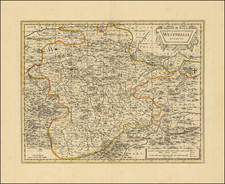
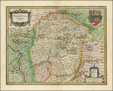
The Upper & Lower Rhine Region
The early 19th century was a time of tremendous political upheaval and territorial reconfiguration in Europe, with many regions experiencing a significant shift in borders and sovereignties. Central Europe, especially the area around the Rhine river, was no exception. Lizars map showcases this shifting landscape, teeming with historical significance, delineating smaller regions, including electorates, duchies, bishoprics, and palatinates.
1. Electorates: The Electorates were territories whose rulers, known as Electors, had traditionally held the privilege of participating in the election of the Holy Roman Emperor.
- Electorate of Trier: Once an electorate, by 1830 this region would have been incorporated into Prussia after the dissolution of the Holy Roman Empire and the subsequent Napoleonic Wars.
- Electorate of Hesse (Hesse-Kassel): Located in the northern part of what is now Hesse, the Electorate of Hesse was another dominant state. However, by the 1830s, it too was facing the winds of change, with larger neighbors exerting increasing influence.
2. Duchies: Duchies were territories ruled by a duke or duchess. They were essential building blocks in the patchwork of the Holy Roman Empire and its aftermath.
- Duchy of Cleves: Situated on the western banks of the Rhine, it was one of the territories amalgamated into the Rhine Province of Prussia by the 1830s.
- Duchy of Berg: Adjacent to Cleves, this duchy too became part of Prussian territories.
- Hesse-Darmstadt (Grand Duchy of Hesse): By 1830, Ludwig II was the Grand Duke of Hesse-Darmstadt. The region was located in the southern part of the present-day state of Hesse in Germany. It had emerged as a powerful entity in the region, particularly following the Congress of Vienna.
- Duchy de Deux Ponts (Duchy of Zweibrücken): Situated in the western part of present-day Germany, by the Rhine's west bank. Historically a duchy in the Holy Roman Empire, by the early 19th century, following Napoleon's reorganizations, much of its territory was incorporated into Bavaria.
- County of Waldeck: Located to the north of Hesse, the County of Waldeck remained a semi-independent entity within the German Confederation in the early 19th century. By the 1830s, it was ruled by George II, who would in 1848 change the title to Prince of Waldeck and Pyrmont.
3. Bishoprics: These were territories governed by a bishop, who often held considerable secular power in addition to religious authority.
- Bishopric of Speyer: While it had traditionally been an influential bishopric, by the 1830s, its secular power was largely diminished, and it was integrated into larger political entities.
- Bishoprick of Fulda: The Bishopric of Fulda was a significant ecclesiastical territory in the Holy Roman Empire. By the end of the 18th century, however, it was secularized. In the reorganizations that followed the Napoleonic Wars, its territories were primarily incorporated into the Electorate of Hesse.
4. Palatinates: The Palatinates were territories ruled by a count palatine, a title which denoted a high-ranking official in the Holy Roman Empire.
- Palatinate of the Rhine (or Electoral Palatinate): Historically significant, by the early 19th century, its territories were divided among several states, including Bavaria and Baden.
As for the rulers of these regions, many would have been absorbed under the overarching sovereignty of the King of Prussia in 1830, who at this time was Friedrich Wilhelm III. Prussia, under his leadership, was a significant player in the German Confederation and had strong alliances with other major German states, particularly after playing a pivotal role in the defeat of Napoleon and the subsequent Congress of Vienna in 1815.
It's important to understand that by 1830, many of these historic entities had either been dissolved or amalgamated into larger political structures, largely due to the outcomes of the Napoleonic Wars and the subsequent reorganization of European territories. The 19th century saw the gradual unification of these territories into what would become the nation of Germany later in the century, under Prussian leadership.
The Lizars were a Scottish family of engravers and printers who produced many views and maps. Daniel Lizars Sr. (1754-1812) was the son of a shoemaker, but he apprenticed with Andrew Bell, a printer and engraver. Lizars set up his own printworks near St. Giles Cathedral and took on his own apprentices, including George Bartholomew, whose son John would go on to found the important mapmaking firm later know as John Bartholomew & Son Ltd.
Daniel Sr. had three sons: Daniel Jr., John, and William Home. He also had a daughter, Jane Home. Daniel Jr. (1793-1875), the youngest of the boys, apprenticed in his father’s shop alongside George Bartholomew. When his father died in 1812, Daniel Jr. took over much of the business, expanding it and specializing in maps. The company went bankrupt in 1832, however, and Daniel emigrated to Canada.
John Lizars (1792-1860), the middle son, studied medicine and became Professor of Surgery at the Royal College of Surgeons of Edinburgh, as well as senior surgeon at the Royal Infirmary of Edinburgh.
William Home Lizars (1788-1859), the eldest, also apprenticed in his father’s shop. After learning engraving, William entered the Trustees’ Academy to learn under John Graham. He was a skilled painter and artist. When his father died, and after his Daniel Jr. left, he carried on printing and invented a method of etching that looks like wood engraving.
![[Frankfurt-am-Rhein] Novam Hanc Territorii Francofurtensis Tabulum Nobilissis Magnificis, Amplimisis Prudentissimisque Dominis . . .](https://storage.googleapis.com/raremaps/img/small/86355.jpg)