|
||

|

|
|

|
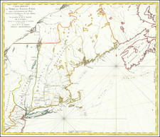
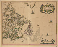
Suite Du Cours Du Fleuve De St. Laurent Depuis Quebec jusqu'au Lac Ontario . . ., by Jacques Nicolas Bellin and published in Paris in 1757, is a detailed cartographic representation of the St. Lawrence River, extending from Quebec to Lake Ontario, with a distinct focus on Montreal. The inclusion of Lake Champlain, Lake George, and the strategic forts of Edward, George, and Carillon, highlights the map's geographic precision and its significance in the context of the ongoing French & Indian War.
At the time of this map's publication, the French & Indian War was underway, a key theater in the larger conflict of the Seven Years' War that pitted European powers against one another. The war saw the French and British empires, along with their respective indigenous allies, vying for territorial dominance in North America.
The portrayal of both Lake Champlain and Lake George is particularly noteworthy. These areas were central to numerous military confrontations during the war. Their delineation on the map provides contemporary observers with a lucid understanding of the topographical challenges and strategic considerations that would have influenced the conduct of both French and British forces in the region.
Jacques-Nicolas Bellin (1703-1772) was among the most important mapmakers of the eighteenth century. In 1721, at only the age of 18, he was appointed Hydrographer to the French Navy. In August 1741, he became the first Ingénieur de la Marine of the Dépôt des cartes et plans de la Marine (the French Hydrographic Office) and was named Official Hydrographer of the French King.
During his term as Official Hydrographer, the Dépôt was the one of the most active centers for the production of sea charts and maps in Europe. Their output included a folio-format sea atlas of France, the Neptune Francois. He also produced a number of sea atlases of the world, including the Atlas Maritime and the Hydrographie Francaise. These gained fame and distinction all over Europe and were republished throughout the eighteenth and even in the nineteenth century.
Bellin also produced smaller format maps such as the 1764 Petit Atlas Maritime, containing 580 finely-detailed charts. He also contributed a number of maps for the 15-volume Histoire Generale des Voyages of Antoine François Prévost.
Bellin set a very high standard of workmanship and accuracy, cementing France's leading role in European cartography and geography during this period. Many of his maps were copied by other mapmakers across the continent.