|
||

|

|
|

|
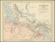
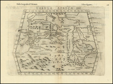
Lake Nyassa, the River Shire &c. from the M.S. Map by Dr. Kirk, published by J. Murray for the Journal of the Royal Geographical Society in 1865, offers an illuminating view into the geography and topography of South Eastern Africa. Engraved by Edward Weller, the map underscores the interconnected water systems of Lake Nyassa, now known as Lake Malawi, and the River Shire, with additional intricate details like the section in the line of the Murchison Rapids.
The 1850s and '60s marked a period of increased European exploration and eventual colonization of the African continent. Within this historical backdrop, the Royal Geographical Society, founded in 1830, played a pivotal role in the dissemination of geographical knowledge about far-flung regions. The map, sourced from Dr. Kirk's manuscript, serves as a testament to the detailed surveys undertaken by explorers during this era, and the Society's efforts to bring these details to a wider academic audience.
Edward Weller's engraving exemplifies the precision and detail for which cartographic renderings of the 19th century are celebrated. Beyond mere geographical delineations, the map extends to provide insights into the region's topographical features. The section detailing the Murchison Rapids of the River Shire, coupled with gradient observations on the River Zambesi from Dr. Kirk's 1860 Barometric readings, offer an analytical depth that showcases the complex terrains and the varying elevations of the region.
In recognizing the vital intersection of geography and history, this map not only charts South Eastern Africa's physical landscape but also subtly underscores the growing European interest in the continent. As a crucial artifact from a transformative period, it mirrors the scientific rigor and the underlying currents of exploration and eventual colonization that would reshape the course of African history.
John Kirk (1832-1922)
Sir John Kirk is the individual referenced in the title of the map. Born in 1832, Dr. John Kirk was a Scottish physician, naturalist, and companion to the famous explorer David Livingstone during his expeditions in Central Africa. He was also the British Consul in Zanzibar and played a significant role in the campaign against the East African slave trade.
Kirk's association with Livingstone, particularly during the Zambezi Expedition from 1858 to 1864, provided him with opportunities to gather extensive geographical, botanical, and medical data from the region. It was during this expedition that he made detailed observations and geographical recordings around Lake Nyassa (Lake Malawi) and the River Shire. These insights significantly enriched European knowledge about these then-lesser-known parts of Africa.
His contributions to the field were recognized by entities like the Royal Geographical Society, which makes the inclusion of his findings in their journal fitting and of notable importance.