|
||

|

|
|

|
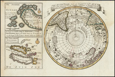
One of the Earliest Obtainable Maps of the North Polar Regions -- Large Inset of Mythical Island of Frisland
Polus Arcticus sive Tract. Septentrionalis. Coloniae, ex Officina Typographica Jani Bussemechers by Matthias Quad, produced in Cologne in 1600, offers a fascinating cartographic depiction of the North Polar regions, including a notable inset detailing the mythical island of Frisland. An interpretation of Mercator's 1595 map, it presents the Arctic through a blend of early scientific understanding, navigational records, and prevalent myths of the age.
During the late 16th and early 17th centuries, Europe's interest in the Arctic regions grew immensely. Expeditions sought northern passages to Asia, and cartographers endeavored to compile the discoveries of such voyages into comprehensive maps. Quad's work embodies this period of exploration and curiosity. Notably, it shows the North Pole as a grand rock within a whirlpool, encircled by islands. The allusion to California, depicted north of the 'El streto de Anian,' demonstrates the incomplete and occasionally misguided understanding Europeans had of the New World's geography.
The decorative flourishes, such as the floral framework and the four corner roundels, enhance the map's aesthetic. The roundels present the title, depictions of the Faeroe and Shetland Isles, and the mythical Frisland. The map's Latin texts detail aspects of the northern territories, citing Greenland's environment, where residents rely on avian and aquatic sustenance, and volcanic activity that produces both constructive and combustible material. Frisland is described as a large, primarily fish-dependent land newly navigated by the English. These textual snippets enrich our understanding of early European perspectives on these northern landscapes.
Matthias Quad (1557-1613), a map publisher based in Cologne, was trained in the Netherlands by Johannes van Doetecum, who also worked with the De Jodes. Quad used many De Jode maps as a base to which he added additional information and decorations. Quad was best known for his atlases, which were part of the first boom in atlases best characterized by Abraham Ortelius’ Theatrum Orbis Terrarum. In 1592, Quad released an atlas of Europe that had 38 maps. He expanded it in 1594 to 50 maps. In 1600, he expanded the collection of maps further still, this time to 82 maps, and called the atlas, Geographisch Handtbuch. All three were small in size, allowing them to compete as cheaper alternatives to the larger atlases of Ortelius, Mercator, and the De Jodes. Quad released one other atlas, in 1608, with 86 maps, the Fascilus Geographicus.
![[North Polar Calotte from a 17th Century Dutch Globe]](https://storage.googleapis.com/raremaps/img/small/70704.jpg)