|
||

|

|
|

|
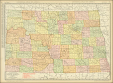
Extremely Rare First Edition of the Greatest Military Map of the Dakotas.
Dakota Territory. Prepared by Order of Maj. Gen. W. S. Hancock, compiled under the auspices of Capt David Porter Heap and lithographed by St. Paul Lith. & Eng. Co., is a detailed representation of the Dakota Territory as it appeared in 1872. The map, a product of exacting military data collection and compilation, presents a thorough examination of the Dakota Territory during a crucial juncture in its history—between the punitive expeditions that followed the Dakota Uprising of 1862 and George Armstrong Custer's 1874 exploration of the Black Hills (on this map marked "Unexplored") and the gold rush that followed.
The late 19th century marked a time of significant transformation for the Dakota Territory. As the United States sought to expand its influence westward, the Dakota Territory became a focal point of military interest, especially following the Dakota Uprising. The ensuing years witnessed an increasing projection of U.S. power onto the northern plains, with a particular emphasis on consolidating and demarcating the territories. This map serves as an invaluable testament to these changes, capturing the intricate network of paths, forts, expedition routes, and delineated reservation boundaries that characterized the region during this era.
Large portions of the territory are designated as reservations, such as the expansive "Reservation for Different Tribes of Sioux Indians," a result of the Treaty of April 29, 1868. In the northwest, the map illustrates the "Reservation for Arickaree Mandan and Gros Ventre Inds," established by an executive order in April 1870. Such delineations offer insights into the relationships and treaties between the U.S. government and the indigenous populations of the region.
The map provides a hint of what the future would hold in the form of a scant line marking the "N.P.R.R. Survey of 1871". The tracks of the North Pacific would reach the Red River Valley in 1873, and despite setbacks during the Panic of '73, the railroad's eventual completion set the stage for statehood in the 1880s.
The maps from which the present tour-de-force overview were compiled are of great rarity themselves. This makes it somewhat difficult to trace the sources for all of the cartography we see here. The northeastern quadrant draws on W.J. Twining's Map of a Portion of Northern Dakota from 1869.
This 1872 depiction of the Dakota Territory exemplifies the interplay of exploration, documentation, and cartographic reproduction that was instrumental in shaping the American West. It not only serves as a geographical guide but also stands as an artifact chronicling the intricate dynamics of territorial consolidation, indigenous treaties, and westward expansion.
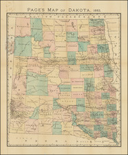
Editions of the Heap (and later Ludlow and Heap) Map of Dakota Territory
From its inception, this was intended as a field map, for use by officers on the ground in the northern Plains. They used these maps as templates for further correction and This map was not disseminated beyond this use in the West. Indeed, one of the four known extant copies of this map was used by General D.S. Stanley on his 1873 Yellowstone Expedition. That example is now held at the American Geographical Society Library.
The map is known in at least three editions, all of which are very rare and bear substantial cartographic changes, but which are readily differentiable through their title blocks:
1872. DAKOTA TERRITORY. PREPARED BY ORDER OF MAJ. GENL. W.S. HANCOCK.
OCLC locates several copies in Wisconsin but these would all seem to be one example, at the AGS Library.
OCLC locates copies at Harvard, Denver Public, and the University of Wyoming.
1878. DAKOTA TERRITORY. PREPARED BY ORDER OF BRIG. GEN'L A.H. TERRY Commanding the Department.
OCLC locates copies at the Library of Congress, Denver Public, Newberry Library, and AGS
David Porter Heap (1843 - 1910) was an army engineer officer attached to the 1871 Barlow party of Yellowstone explorers and co-author of the resulting official report. In February 1870, he was appointed chief engineer of the Department of Dakota, preceding Ludlow in this position. In this role, he oversaw the compilation of the great 1872 military map of Dakota Territory order by Major General Hancock. Heap's name also appears as the primary compiler of a Montana Territory map, published in 1872. Later that year, he had been relocated to Charleston, South Carolina, serving the Corps of Engineers and River and Harbor improvement projects in the Southeast, where he served as the successor to William Ludlow, who was re-assigned to the west on November 14, 1872.
![[ Western United States -- Massive Idaho Territory ]](https://storage.googleapis.com/raremaps/img/small/99057.jpg)