


|
||

|

|
|

|
English Biblical Art
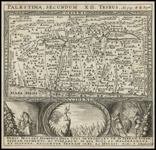
Scarce map of the Holy Land from a King James version of the Holy Bible published in London.
The present map is one of the first maps of the Holy Land published in England.
The map showcases the biblical Holy Land, namely Jerusalem, Sodom, and the Dead Sea. The tribes of the children of Israel are listed on the right side. Shows the routes of Abraham and the children of Israel. Text in English on verso gives a detailed description of Canaan. The title cartouche is flanked by Moses and Aaron at each side, with a quote below reading "The Law was given by Moses but grace and truth came by Jesus Christ John 1:17."
The map shows Moses leading the tribes of Israel from Egypt across the Red Sea, with the subsequent 40-year journey shown on a year-by-year basis. Several other historical vignettes are shown such as the sites of holy wars and religious meetings of the twelve tribes.
Includes an inset view of Jerusalem and its vicinity with Calvary and the tree where Judas killed himself featured. Stylized depictions of contemporary sailing ships and sea monsters populate the water beneath this inset.
A fine illustration of the area with the inclusion of interesting historical context of one of the earliest artistic works of the King James Bible.
John Speed (1551 or '52 - 28 July 1629) was the best known English mapmaker of the Stuart period. Speed came to mapmaking late in life, producing his first maps in the 1590s and entering the trade in earnest when he was almost 60 years old.
John Speed's fame, which continues to this day, lies with two atlases, The Theatre of the Empire of Great Britaine (first published 1612), and the Prospect of the Most Famous Parts of the World (1627). While The Theatre ... started as solely a county atlas, it grew into an impressive world atlas with the inclusion of the Prospect in 1627. The plates for the atlas passed through many hands in the 17th century, and the book finally reached its apotheosis in 1676 when it was published by Thomas Bassett and Richard Chiswell, with a number of important maps added for the first time.

![Arabia, Petraea et Deserta [Saudi Arabia, etc.]](https://storage.googleapis.com/raremaps/img/small/87833.jpg)
![(Nuremberg Chronicle) [Geneology of the Virgin Mary]](https://storage.googleapis.com/raremaps/img/small/98722.jpg)