|
||

|

|
|

|
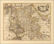
This map provides a detailed representation of Westphalia as it appeared circa 1828. The map is intricately marked with various geopolitical boundaries and similar details.
The map also makes use of a vibrant color scheme to signify political dominions:
-
Blue: Territory under Prussian control. By the 1830s, Prussia had expanded its dominion in Westphalia as a result of territorial gains from the Congress of Vienna in 1815.
-
Red: Territory belonging to the Kingdom of Hanover. Hanover, with its dynastic ties to Britain, was an important geopolitical player in northern Germany during this period.
-
Yellow: Dutch territories, including areas around Bremen, the Bishoprick of Liège, and the Duchy of Limburg. These regions had their own unique histories and were at various points influenced by or under the control of the Dutch.
The map distinctly outlines counties, principalities, and bishopricks, highlighting the fragmented political landscape of Westphalia, which was made up of multiple small entities, each under the governance of its own ruler or religious leader. Numerous towns are portrayed, from major cities to minor settlements, illustrating the populated network that constituted Westphalia during this era. The natural landscape prominently features many rivers, which, beyond being geographical landmarks, acted as vital routes for trade and transportation. A web of main and secondary roads showcases the region's connectivity and its advanced infrastructure of the time. Furthermore, expansive green areas represent Westphalia's forests, serving both as valuable resources and natural barriers in certain locales.
History of Westphalia (1800-1850):
At the turn of the 19th century, the region of Westphalia, like much of the Holy Roman Empire, was a patchwork of numerous small states, bishoprics, and territories. The Napoleonic era brought about significant change:
-
In 1807, after Napoleon's victories in Germany, the Kingdom of Westphalia was created, with Napoleon's brother, Jérôme Bonaparte, as its king. This kingdom was a French satellite state and incorporated large portions of the region.
-
The Congress of Vienna in 1815 played a crucial role in redrawing the map of Europe after the Napoleonic Wars. As a result, much of Westphalia became part of the Kingdom of Prussia, strengthening its position in northern Germany. Other parts, as noted on the map, went to Hanover and the Netherlands.
Between 1815 and 1850, Westphalia, now largely under Prussian rule, saw the rise of industrialization, with the growth of coal mining and steel production in the Ruhr area. The spread of railways further boosted its economic significance. Moreover, the region experienced the first stirrings of German nationalism and the broader movements for political and social reform that would shape the trajectory of German history throughout the 19th century.
Netherlands' Territories in Westphalia:
-
Bishopric of Liège: Prior to the French Revolution, the Prince-Bishopric of Liège was a state of the Holy Roman Empire. However, during the Napoleonic era, it was annexed by France. After Napoleon's defeat, the Congress of Vienna did not restore the Prince-Bishopric. Instead, most of its territory (located primarily in modern-day Belgium) was given to the United Kingdom of the Netherlands, which was created in 1815 as a buffer state against France.
-
Duchy of Limburg: After the Napoleonic Wars, the Congress of Vienna created the Duchy of Limburg as part of the German Confederation but under the sovereignty of the King of the Netherlands. This dual status made Limburg a unique territory, being both part of the German Confederation and ruled by the Dutch king.
Hanover's Territories in Westphalia:
-
Kingdom of Hanover: After the Congress of Vienna, the Kingdom of Hanover was established in 1814. It was a successor to the former Electorate of Hanover. George III of the United Kingdom was the Elector of Hanover, and with the end of the Holy Roman Empire, Hanover was elevated to a kingdom, which was ruled in personal union with the United Kingdom until 1837.
-
Territorial Acquisitions: Post-Napoleonic rearrangements resulted in Hanover gaining territories in Westphalia. These were mostly to the north and east of its previous boundaries, expanding the kingdom's size and strategic significance in northern Germany.
During this period, both the Netherlands and Hanover, through their territorial claims in Westphalia and beyond, were pivotal in the balance of power in post-Napoleonic Europe. While the Dutch were establishing a revived presence on the European continent with the formation of the United Kingdom of the Netherlands, Hanover was simultaneously solidifying its position as a significant kingdom in northern Germany, with close dynastic ties to Britain.
The Lizars were a Scottish family of engravers and printers who produced many views and maps. Daniel Lizars Sr. (1754-1812) was the son of a shoemaker, but he apprenticed with Andrew Bell, a printer and engraver. Lizars set up his own printworks near St. Giles Cathedral and took on his own apprentices, including George Bartholomew, whose son John would go on to found the important mapmaking firm later know as John Bartholomew & Son Ltd.
Daniel Sr. had three sons: Daniel Jr., John, and William Home. He also had a daughter, Jane Home. Daniel Jr. (1793-1875), the youngest of the boys, apprenticed in his father’s shop alongside George Bartholomew. When his father died in 1812, Daniel Jr. took over much of the business, expanding it and specializing in maps. The company went bankrupt in 1832, however, and Daniel emigrated to Canada.
John Lizars (1792-1860), the middle son, studied medicine and became Professor of Surgery at the Royal College of Surgeons of Edinburgh, as well as senior surgeon at the Royal Infirmary of Edinburgh.
William Home Lizars (1788-1859), the eldest, also apprenticed in his father’s shop. After learning engraving, William entered the Trustees’ Academy to learn under John Graham. He was a skilled painter and artist. When his father died, and after his Daniel Jr. left, he carried on printing and invented a method of etching that looks like wood engraving.
![[ Southern Baltic Sea ] De Custen van Schoonen en Swede van Valsterboen tot Christianopolis Bornholm en de Custen van Pomeren van't Eylant Rugen tot Rygs-hooft](https://storage.googleapis.com/raremaps/img/small/67743.jpg)
![[Denmark and Southern Sweden] Danorum Marca, vel Cimbricum, aut Daniae Regnum . . . M. D. LXXXV.](https://storage.googleapis.com/raremaps/img/small/91201.jpg)